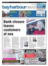
Bay Harbour: August 29, 2024

Transform your PDFs into Flipbooks and boost your revenue!
Leverage SEO-optimized Flipbooks, powerful backlinks, and multimedia content to professionally showcase your products and significantly increase your reach.
<strong>Bay</strong> <strong>Harbour</strong> News Thursday <strong>August</strong> <strong>29</strong> <strong>2024</strong><br />
8<br />
TREASURES FROM THE PAST<br />
Sumner Rd a tricky route to create<br />
Getting from the port to<br />
the plains was critical for<br />
early settlers. In part one of<br />
a two-part series, J.C Betts<br />
details the creation of the<br />
Sumner Rd, 1849-1867<br />
THE MOST pressing problem<br />
for Waitaha Canterbury’s first<br />
settlers was access from the<br />
port to the plains and the site of<br />
Ōtautahi Christchurch.<br />
In July 1849, Captain Thomas<br />
first viewed a route via a 600ft<br />
pass suggested by Master Evans,<br />
of the survey ship, Her Majesty’s<br />
Paddle Steamer, HMPSAcheron.<br />
Thomas believed a 4-mile road<br />
over Tapuaeharuru Evans Pass<br />
(with a tunnel through the<br />
summit) to Matuku Takotako<br />
Sumner and the remaining<br />
7 miles to the site of the city<br />
could be built in time for the<br />
immigrants’ arrival.<br />
Labourers were brought from<br />
Te Whanganui-a-Tara Wellington<br />
– about half of them were<br />
Māori. At first, tangata whenua<br />
appear to have been dubious<br />
about joining the road gangs.<br />
However, after a few weeks’ work<br />
Thomas wrote: “The natives<br />
residing here who have hitherto<br />
held back are now so well pleased<br />
with the treatment of the working<br />
natives that they are now<br />
joining us in considerable numbers.”<br />
(Colin Amodeo, Tracking<br />
Captain Thomas, Caxton Press,<br />
2017, p.175.)<br />
In November, one gang<br />
downed tools, apparently offended<br />
by their supervisor’s swearing<br />
– the man, Joseph Compton,<br />
left his job. Another road gang<br />
worked on forming the uphill<br />
road east from Ōhinehou Lyttelton’s<br />
Oxford St towards Officers<br />
Point, a spur of very hard rock.<br />
By blasting, they succeeded<br />
in forming the road as far as<br />
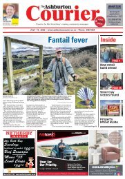
On the Sumner Road, Canterbury, New Zealand by Sir<br />
William Fox January 1851. Te Ūaka Lyttelton Museum ref<br />
14991.3 https://www.teuaka.org.nz/onlinecollection/1136830<br />
Sticking Point, known today<br />
as Windy Point, where a plane<br />
table affords interpretation of the<br />
harbour’s features. No 2 Road<br />
Party began at the top of the<br />
pass, flattening the summit and<br />
starting on the downhill sections<br />
on both sides.<br />
The day before the settlers’<br />
arrival, Chief Agent JR Godley<br />
dealt with a dispute – the<br />
European workers objected to<br />
Māori receiving the same wage<br />
as themselves, sixpence an hour.<br />
Godley fired the dissidents and<br />
hired more Māori. The European<br />
men returned to work the next<br />
day. Godley described the Māori<br />
at work, stating “they struck,<br />
shovelled &c., altogether, keeping<br />
time to a song . . . most civil,<br />
good-natured fellows, laughing<br />
immoderately at our questions<br />
and chattering broken English<br />
very fast in reply”. (Amodeo,<br />
ibid. p.193.)<br />
By late 1850, it was obvious<br />
that the road would not be completed<br />
in time.<br />
Charlotte Godley wrote: “The<br />
great road is still very unfinished;<br />
several shoulders of rock<br />
that come in the way, and have to<br />
be blasted, stop it up completely,<br />
and in some places along the line<br />
even the path is quite a climb,<br />
with a rope to pull yourself up<br />
by”. (Charlotte Godley, Letters<br />
from Early New Zealand, Whitcombe<br />
& Tombs, 1951, p.139.)<br />
When the immigrants arrived<br />
in December 1850, the Bridle<br />
Path to Ōpāwaho Heathcote was<br />
the only land route to the plains.<br />
The Canterbury Association was<br />
wound up in 1853 and the new<br />
Provincial Council under Superintendent<br />
J.E FitzGerald pressed<br />
on with the Sumner Rd.<br />
Provincial engineer Edward<br />
Dobson chose a radically<br />
different (but much cheaper)<br />
route. The road on the harbour<br />
side skirted the coast to Gollans<br />
<strong>Bay</strong> at a level lower than the<br />
problematic bluffs, then rose to<br />
the top of the pass in a series of<br />
tight zig-zags. The original plan<br />
to build a tunnel through the<br />
summit never happened due to<br />
lack of funds.<br />
On the Sumner side, Dobson<br />
chose a different route on the<br />
other side of the valley “modifying<br />
his gradient according to<br />
the character of the hill-side”, according<br />
to C.C Bowen, Lyttelton<br />
Times, September 8, 1902.<br />
This resulted in a very steep<br />
section and a hairpin bend<br />
near the summit. The original,<br />
partly-formed line is now the<br />
Captain Thomas Track.<br />
FitzGerald was so determined<br />
to see the road finished before he<br />
left for England, that in <strong>August</strong><br />
1857 he “insisted on risking his<br />
own life and that of his friends<br />
by driving a tandem over the<br />
half finished zig-zag . . . with the<br />
assistance of volunteer grooms<br />
hanging on to the horses’ heads<br />
and a stalwart crowd hanging on<br />
to the dog cart behind”. (Lyttelton<br />
Times, September 8, 1902.)<br />
FitzGerald’s vehicle had two<br />
six-foot high red wheels and was<br />
known as the “irculating Medium”.<br />
Pedestrians accompanied<br />
the travellers and they were<br />
given a rousing welcome and ceremonial<br />
dinner in Lyttelton.<br />
When FitzGerald returned<br />
to New Zealand in 1861 he<br />
found that Superintendent W.S<br />
Moorhouse had started work<br />
on a railway line and tunnel<br />
to Lyttelton via Ōpāwaho<br />
Heathcote. FitzGerald so<br />
strongly disapproved that,<br />
despite having been the first<br />
editor of the Lyttelton Times, he<br />
started a second newspaper, The<br />
Press, in order to criticise the<br />
railway.<br />
The first Sumner Rd at least<br />
provided a daily carriage and<br />
mail service.<br />
Lady Barker made the<br />
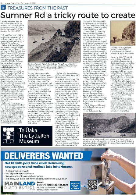
Sticking Point, Lyttelton<br />
<strong>Harbour</strong>, circa 1868,<br />
Christchurch, by Daniel<br />
Mundy. Te Papa (O.009606)<br />
journey in 1865. “We started<br />
from Lyttelton and almost<br />
immediately began to ascend<br />
the zig-zag. It was a tremendous<br />
pull for the poor horses, who<br />
however never flinched; at the<br />
steepest pinch the gentlemen<br />
were requested to get out and<br />
walk, which they did, and at<br />
length we reached the top . . .<br />
the driver looked to the harness<br />
of his horses, put on a very<br />
powerful double break, and we<br />
began the descent, which, I must<br />
say, I thought we took much too<br />
quickly, especially as at every<br />
turn of the road some anecdote<br />
was forthcoming of an upset or<br />
accident.” (Lady Barker, Station<br />
Life in New Zealand, Virago<br />
1984, pp 19-20.)<br />
With the completion of the<br />
Moorhouse Rail Tunnel in 1867,<br />
improving the route was no<br />
longer a priority, but after 70<br />
years, and the advent of motor<br />
transport, attention was again<br />
given to the Sumner Rd.<br />
Arrival of the first four ships at Lyttelton in 1850, from a<br />
drawing by Mary Townsend, showing Sumner Rd. Te Ūaka<br />
Lyttelton Museum ref 14625.6 https://www.teuaka.org.nz/<br />
online-collection/1135495<br />
DELIVERERS WANTED<br />
Get fit with part time work delivering<br />
newspapers and mailers into letterboxes.<br />
• Regular weekly work<br />
• No experience necessary<br />
• We are a locally owned company<br />
• It’s easy, we drop the newspapers/mailers to your door<br />
Email:<br />
deliveries@alliedpress.co.nz<br />
Include your name, address,<br />
email, phone number<br />
OR SCAN<br />
THE QR<br />
CODE<br />
TO APPLY