Sotm 2010 the tyranny of place
2 likes•1,804 views

The document explores the concept of 'place' in geography, highlighting its relational nature and the impact of local context on contributions to geospatial data platforms like OpenStreetMap. It discusses how spatial and non-spatial applications rely on user-generated content, where the characteristics of places affect data quality and coverage, particularly emphasizing disparities in representation across different socio-economic areas. Additionally, the findings suggest that the motivations for contributing to mapping projects are influenced by personal connections to local environments.

Sotm 2010 the tyranny of place
- 1. The Tyranny of place Muki Haklay, UCLNamaRaj Budhathoki, University of Illinois, Urbana-Champaign Vyron Antoniou, UCL
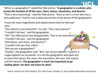
- 2. "What is a geographer?" asked the little prince. "A geographer is a scholar who knows the location of all the seas, rivers, towns, mountains, and deserts." "That is very interesting," said the little prince. "Here at last is a man who has a real profession!" And he cast a look around him at the planet of the geographer. It was the most magnificent and stately planet that he had ever seen. "Your planet is very beautiful," he said. "Has it any oceans?" "I couldn't tell you," said the geographer. "Ah!" The little prince was disappointed. "Has it any mountains?" "I couldn't tell you," said the geographer. "And towns, and rivers, and deserts?" "I couldn't tell you that, either." "But you are a geographer!" "Exactly," the geographer said. "But I am not an explorer. I haven't a single explorer on my planet. It is not the geographer who goes out to count the towns, the rivers, the mountains, the seas, the oceans, and the deserts. The geographer is much too important to go loafing about. He does not leave his desk.”Source: Antoine de Saint-Exupéry, The Little Prince, Chapter 15, http://www.villahostels.com/prince/
- 3. Place / SpaceCore concepts in Geography Spatial Science – searching for universal laws, or treating all locations in the same way ‘Place is defined as the site of relations between attributes. If so, then the argument for any kind of independent spatial science ... falls away entirely.’ (David Harvey, 1996, p. 263)
- 4. The relational view of space‘One way of seeing ‘places’ is as on the surface of maps: Samarkand is there, the United States of America (finger outlining a boundary) is here. But, to escape from an imagination of space as a surface is to abandon also that view of place. If space is rather simultaneity of stories-so-far, then places are collections of those stories, articulations within the wider power-geometries of space. Their character will be a product of these intersections within that wider setting, and of what is made of them. And, too, of the non-meetings-up, the disconnections and the relations not established, the exclusions. All this contributes to the specificity of place.’Doreen Massey, 2005, ‘For Space’, p. 131
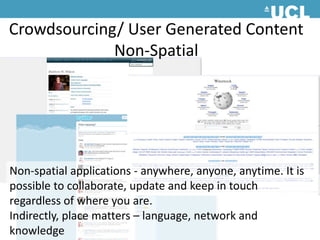
- 5. Crowdsourcing/ User Generated ContentNon-SpatialNon-spatial applications - anywhere, anyone, anytime. It is possible to collaborate, update and keep in touch regardless of where you are.Indirectly, place matters – language, network and knowledge
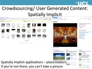
- 6. Crowdsourcing/ User Generated Content:Spatially Implicit Spatially Implicit applications – place matters: if you’re not there, you can’t take a picture
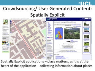
- 7. Crowdsourcing/ User Generated Content:Spatially Explicit Spatially Explicit applications – place matters, as it is at the heart of the application – collecting information about places
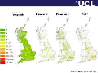
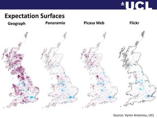
- 8. FlickrPicasa WebPanoramioGeographSource: Vyron Antoniou, UCL
- 9. Expectation SurfacesFlickrPicasa WebPanoramioGeographSource: Vyron Antoniou, UCL
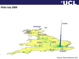
- 10. Flickr July 2009Source: Vyron Antoniou, UCL
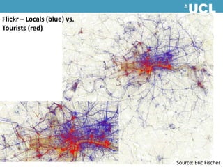
- 11. Flickr– Locals (blue) vs. Tourists (red) Source: Eric Fischer
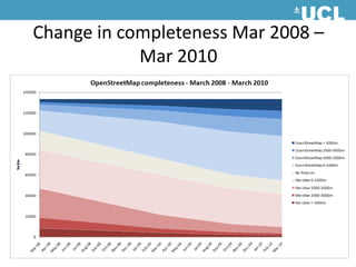
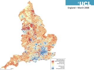
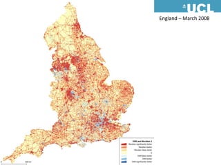
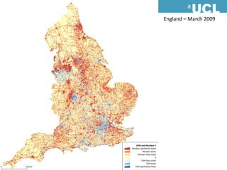
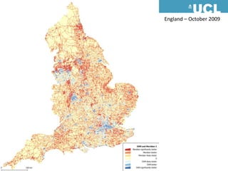
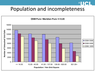
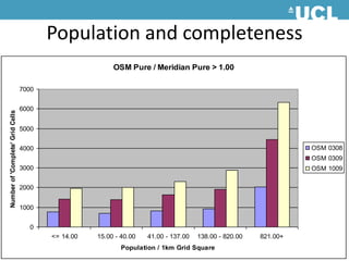
- 12. Change in completeness Mar 2008 – Mar 2010
- 13. England – March 2008
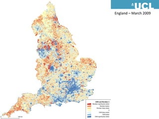
- 14. England – March 2009
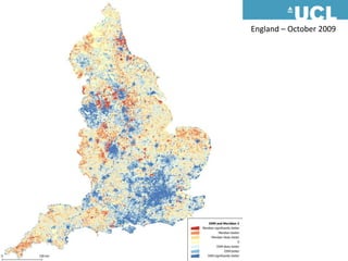
- 15. England – October 2009
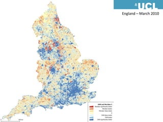
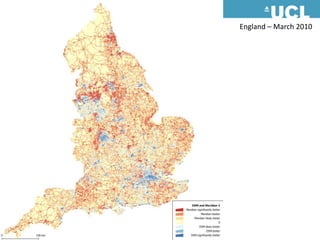
- 16. England – March 2010
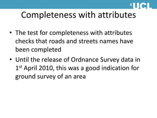
- 17. Completeness with attributesThe test for completeness with attributes checks that roads and streets names have been completedUntil the release of Ordnance Survey data in 1st April 2010, this was a good indication for ground survey of an area
- 18. England – March 2008
- 19. England – March 2009
- 20. England – October 2009
- 21. England – March 2010
- 22. England – March 2010
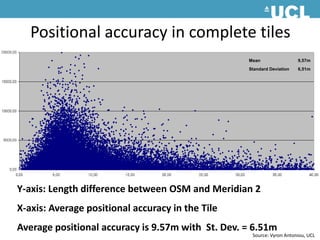
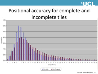
- 23. Positional accuracy in complete tiles Y-axis: Length difference between OSM and Meridian 2 X-axis: Average positional accuracy in the TileAverage positional accuracy is 9.57m with St. Dev. = 6.51mSource: Vyron Antoniou, UCL
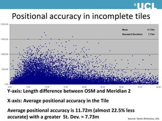
- 24. Positional accuracy in incomplete tiles Y-axis: Length difference between OSM and Meridian 2 X-axis: Average positional accuracy in the TileAverage positional accuracy is 11.72m (almost 22.5% less accurate) with a greater St. Dev. = 7.73mSource: Vyron Antoniou, UCL
- 25. Positional accuracy for complete and incomplete tiles Source: Vyron Antoniou, UCL
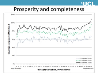
- 29. Taking stockMapping happens in high population density areas, with some super high activity areasLocal familiarity influence data collectionRegardless of the spatial ‘explicitness’ of an application, data quality and coverage will focus on ‘active’ places (city centres) Suburbs and rural areas are underrepresented Disparity between socio-economic places
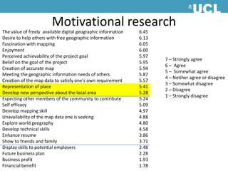
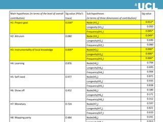
- 30. Motivational researchThe value of freely available digital geographic information 6.45 Desire to help others with free geographic information 6.13 Fascination with mapping 6.05 Enjoyment 6.00 Perceived achievability of the project goal 5.97 Belief on the goal of the project 5.95 Creation of accurate map 5.94 Meeting the geographic information needs of others 5.87 Creation of the map data to satisfy one's own requirement 5.57 Representation of place 5.41 Develop new perspective about the local area 5.28 Expecting other members of the community to contribute 5.24 Self efficacy 5.09 Develop mapping skill 4.97 Unavailability of the map data one is seeking 4.88 Explore world geography 4.80 Develop technical skills 4.58 Enhance resume 3.86 Show to friends and family 3.71 Display skills to potential employers 2.48 Future business plan 2.28 Business profit 1.93 Financial benefit 1.78 7 – Strongly agree6 – Agree5 – Somewhat agree4 – Neither agree or disagree3 – Somewhat disagree2 – Disagree 1 – Strongly disagree
- 32. The Tyranny of PlaceIn spatially explicit projects, the place where the participant live and work have a disproportional impact on what and how much they contributePlace not just dictates what they know but also influences motivation
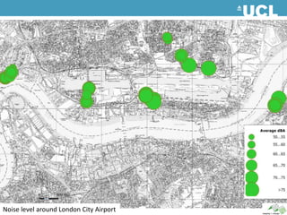
- 36. Noise level around London City Airport
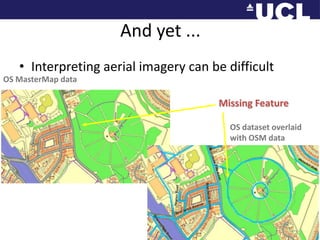
- 40. And yet ...Interpreting aerial imagery can be difficultOS MasterMap dataMissing FeatureOS dataset overlaid with OSM data
- 41. And yet ...Interpreting aerial imagery can be difficultAerial Imagery cannot reveal local details, and secondary sources do not incorporate local knowledgeWith secondary sources, you are at the mercy of the details, generalisation and other cartographic decisions of the producer
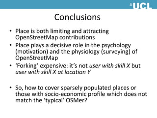
- 42. ConclusionsPlace is both limiting and attracting OpenStreetMap contributionsPlace plays a decisive role in the psychology (motivation) and the physiology (surveying) of OpenStreetMap‘Forking’ expensive: it’s not user with skill X but user with skill X at location YSo, how to cover sparsely populated places or those with socio-economic profile which does not match the ‘typical’ OSMer?
Editor's Notes
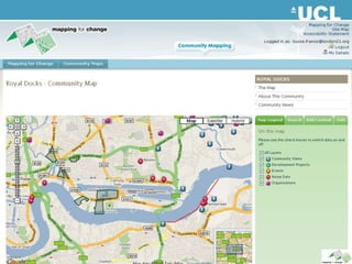
- #35: The Royal Docks Community map has recently been used by community members to record the levels of noise they are being exposed to
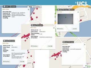
- #36: Some of the readings and comments that have been added to the map.
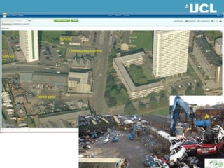
- #38: The final example are from the Pepys Estate in Lewisham, where the residents are concerns with the noise and pollution from a scrap yard which is located near the community centre and a school.