Medieval cities
Download as PPTX, PDF•15 likes•15,880 views

The medieval city of Jodhpur, India was founded in 1459 by Rao Jodha on a rocky hill where he built the Mehrangarh Fort. Over time, the city expanded with the addition of walls, gates, residential areas segregated by caste, and infrastructure like lakes and stepwells to supply water. Jodhpur benefited economically and culturally from its position on trade routes between Delhi and Gujarat. In later centuries, the city continued growing outside its walls under Mughal rule and British influence, as new palaces, courts, and other buildings were constructed.


Medieval cities
- 1. MEDIEVAL CITIES OF INDIA BHAVANA MAINI ISHA ZEHRA MAHDI
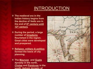
- 2. INTRODUCTION The medieval era in the Indian history begins from the decline of Vedic era in the end of 6th century until 12th century. During the period, a large number of kingdoms flourished in the region. Great cities were developed and prospered. Religion, military & politics formed the basis of city planning. The Mauryan and Gupta dynasty in the north, Cholas and Pandyvas in the south, Aghom dynasty of
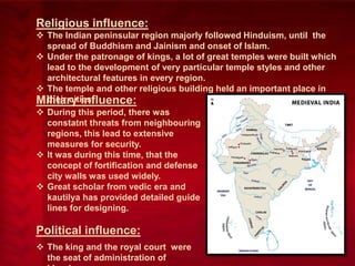
- 3. Religious influence: The Indian peninsular region majorly followed Hinduism, until the spread of Buddhism and Jainism and onset of Islam. Under the patronage of kings, a lot of great temples were built which lead to the development of very particular temple styles and other architectural features in every region. The temple and other religious building held an important place in their cities. Military influence: During this period, there was constatnt threats from neighbouring regions, this lead to extensive measures for security. It was during this time, that the concept of fortification and defense city walls was used widely. Great scholar from vedic era and kautilya has provided detailed guide lines for designing. Political influence: The king and the royal court were the seat of administration of
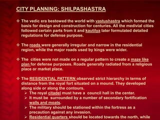
- 4. CITY PLANNING: SHILPASHASTRA The vedic era bestowed the world with vastushastra which formed the basis for design and construction for centuries. All the medivial cities followed certain parts from it and kautilya later formulated detailed regulations for defense purpose. The roads were generally irregular and narrow in the residential region, while the major roads used by kings were wider. The cities were not made on a regular pattern to create a maze like plan for defense purposes. Roads generally radiated from a religious place or market place. The RESIDENTIAL PATTERN observed strict hierarchy in terms of distance from the royal fort situated on a mound. They developed along side or along the contours. The royal citadel must have a council hall in the center. It must be surrounded by a number of secondary fortification walls and moats. The military should be stationed within the fortress as a precaution against any invasion. Residential quarters should be located towards the north, while
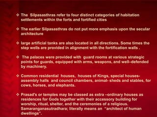
- 5. The Silpasasthras refer to four distinct categories of habitation settlements within the forts and fortified cities The earlier Silpasasthras do not put more emphasis upon the secular architecture large artificial tanks are also located in all directions. Some times the step wells are provided in alignment with the fortification walls . The palaces were provided with guard rooms at various strategic points for guards, equipped with arms, weapons, and well–defended by machinery. Common residential houses, houses of Kings, special housesassembly halls and council chambers, animal- sheds and stables, for cows, horses, and elephants. Prasad's or temples may be classed as extra –ordinary houses as residences for Gods together with their accessory building for worship, ritual, shelter, and the ceremonies of a religious. Samaranganasutradhara; literally means an ―architect of human dwellings‖.
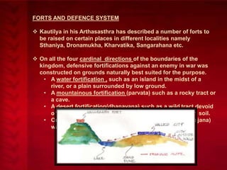
- 6. FORTS AND DEFENCE SYSTEM Kautilya in his Arthasasthra has described a number of forts to be raised on certain places in different localities namely Sthaniya, Dronamukha, Kharvatika, Sangarahana etc. On all the four cardinal directions of the boundaries of the kingdom, defensive fortifications against an enemy in war was constructed on grounds naturally best suited for the purpose. • A water fortification , such as an island in the midst of a river, or a plain surrounded by low ground. • A mountainous fortification (parvata) such as a rocky tract or a cave. • A desert fortification(dhanavana) such as a wild tract devoid of water and overgrown with thicket growing in barren soil. • Or a forest fortification (vanadurga) full of wagtail (khajana) water and thickets.
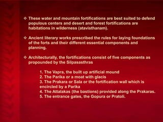
- 7. These water and mountain fortifications are best suited to defend populous centers and desert and forest fortifications are habitations in wilderness (atavisthanam). Ancient literary works prescribed the rules for laying foundations of the forts and their different essential components and planning. Architecturally, the fortifications consist of five components as propounded by the Silpasasthras 1. The Vapra, the built up artificial mound 2. The Parika or a moat with glacis 3. The Prakara or Sala or the fortification wall which is encircled by a Parika 4. The Attalakas (the bastions) provided along the Prakaras. 5. The entrance gates, the Gopura or Pratoli.
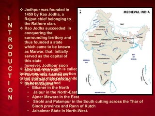
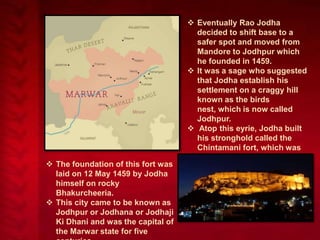
- 9. I N T R O D U C T I O N Jodhpur was founded in 1459 by Rao Jodha, a Rajput chief belonging to the Rathore clan. Rao Jodha succeeded in conquering the surrounding territory and thus founded a state which came to be known as Marwar, that initially served as the capital of this state however, Jodhpur soon The land area which is called jodhpur took over that role. today was only a small portion of the The city was located on grand marwar state before independence. the strategic road linking Its borders touched Delhi to Gujarat. • Bikaner in the North • Jaipur in the North-East • Ajmer Mewara in the East • Sirohi and Palampur in the South cutting across the Thar of Sindh province and Rann of Kutch • Jaisalmer State in North-West.
- 10. The foundation of this fort was laid on 12 May 1459 by Jodha himself on rocky Bhakurcheeria. This city came to be known as Jodhpur or Jodhana or Jodhaji Ki Dhani and was the capital of the Marwar state for five Eventually Rao Jodha decided to shift base to a safer spot and moved from Mandore to Jodhpur which he founded in 1459. It was a sage who suggested that Jodha establish his settlement on a craggy hill known as the birds nest, which is now called Jodhpur. Atop this eyrie, Jodha built his stronghold called the Chintamani fort, which was later called Mehrangarh. This fort was situated 6 miles south of Mandore on a mountain called Chidiyanath ki Tonk.
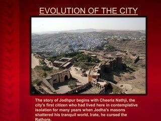
- 11. EVOLUTION OF THE CITY The story of Jodhpur begins with Cheeria Nathji, the city's first citizen who had lived here in contemplative isolation for many years when Jodha's masons shattered his tranquil world. Irate, he cursed the Rathore,
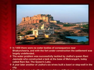
- 12. In 1459 there were no water bodies of consequence near Bhakurcheeria, and with the fort under construction the settlement was largely undefended. The water problem was successfully tackled by Jodha's queen Rani Jasmade who constructed a tank at the base of Mehrangarh, today called Rani Sar, The Queen's Lake. A year later another of Jodha's six wives built a baori or step-well in the city.
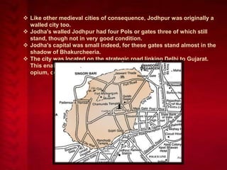
- 13. Like other medieval cities of consequence, Jodhpur was originally a walled city too. Jodha's walled Jodhpur had four Pols or gates three of which still stand, though not in very good condition. Jodha's capital was small indeed, for these gates stand almost in the shadow of Bhakurcheeria. The city was located on the strategic road linking Delhi to Gujarat. This enabled it to profit from a flourishing trade in opium, copper, silk, sandals, date palms and coffee.
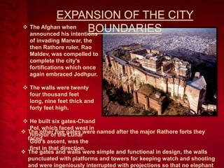
- 14. EXPANSION OF THE CITY The Afghan when BOUNDARIES announced his intentions of invading Marwar, the then Rathore ruler, Rao Maldev, was compelled to complete the city's fortifications which once again embraced Jodhpur. The walls were twenty four thousand feet long, nine feet thick and forty feet high. He built six gates-Chand Pol, which faced west in The other five gates were named after the major Rathore forts they honour of the Lunar faced. God's ascent, was the first in that direction. The gates and walls were simple and functional in design, the walls punctuated with platforms and towers for keeping watch and shooting and were ingeniously interrupted with projections so that no elephant
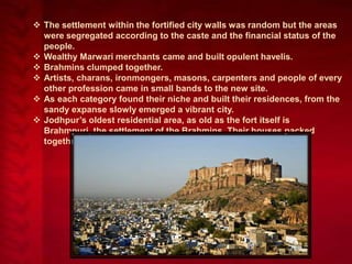
- 15. The settlement within the fortified city walls was random but the areas were segregated according to the caste and the financial status of the people. Wealthy Marwari merchants came and built opulent havelis. Brahmins clumped together. Artists, charans, ironmongers, masons, carpenters and people of every other profession came in small bands to the new site. As each category found their niche and built their residences, from the sandy expanse slowly emerged a vibrant city. Jodhpur’s oldest residential area, as old as the fort itself is Brahmpuri, the settlement of the Brahmins. Their houses packed together along narrow streets.
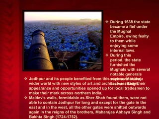
- 16. During 1638 the state became a fief under the Mughal Empire, owing fealty to them while enjoying some internal laws. During this period, the state furnished the Mughals with several notable generals Jodhpur and its people benefited from this such as Maharaja exposure to the wider world with new styles of art and architecture made their Jaswant Singh. appearance and opportunities opened up for local tradesmen to make their mark across northern India. Maldev's walls, formidable as Sher Shah found them, were not able to contain Jodhpur for long and except for the gate in the east and in the west, all the other gates were shifted outwards again in the reigns of the brothers, Maharajas Abhaya Singh and Bakhta Singh (1724-1752).
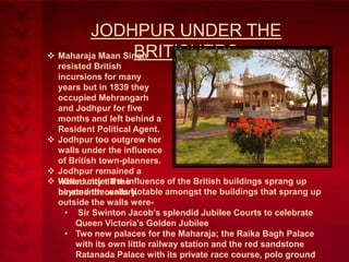
- 17. JODHPUR UNDER THE BRITISHERS Maharaja Maan Singh resisted British incursions for many years but in 1839 they occupied Mehrangarh and Jodhpur for five months and left behind a Resident Political Agent. Jodhpur too outgrew her walls under the influence of British town-planners. Jodhpur remained a When under the influence of the British buildings sprang up walled city till the beyond the walls Notable amongst the buildings that sprang up nineteenth century. outside the walls were• Sir Swinton Jacob's splendid Jubilee Courts to celebrate Queen Victoria's Golden Jubilee • Two new palaces for the Maharaja; the Raika Bagh Palace with its own little railway station and the red sandstone Ratanada Palace with its private race course, polo ground
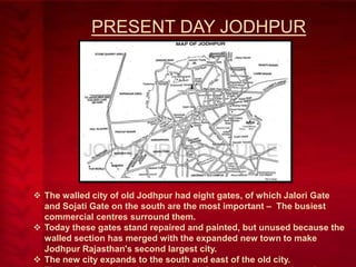
- 18. PRESENT DAY JODHPUR The walled city of old Jodhpur had eight gates, of which Jalori Gate and Sojati Gate on the south are the most important – The busiest commercial centres surround them. Today these gates stand repaired and painted, but unused because the walled section has merged with the expanded new town to make Jodhpur Rajasthan's second largest city. The new city expands to the south and east of the old city.
- 19. VARANASI
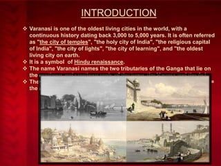
- 20. INTRODUCTION Varanasi is one of the oldest living cities in the world, with a continuous history dating back 3,000 to 5,000 years. It is often referred as "the city of temples", "the holy city of India", "the religious capital of India", "the city of lights", "the city of learning", and "the oldest living city on earth. It is a symbol of Hindu renaissance. The name Varanasi names the two tributaries of the Ganga that lie on the northern and southern ends of the town, the Varuna and the Asi. They guard the city against the entry of evil: Asi = the sword; Varuna = the averter.
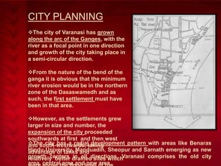
- 21. CITY PLANNING The city of Varanasi has grown along the arc of the Ganges, with the river as a focal point in one direction and growth of the city taking place in a semi-circular direction. From the nature of the bend of the ganga it is obvious that the minimum river erosion would be in the northern zone of the Dasaswamedh and as such, the first settlement must have been in that area. However, as the settlements grew larger in size and number, the expansion of the city proceeded southwards at first and then west The city has a radialtaking and south-westwards, development pattern with areas like Benaras Hindu University, Manduadih, Sheopur and Sarnath emerging as new advantage of tanks and growth centers drained sites which relatively better in all directions. Varanasi comprises the old city area, central area and new area.
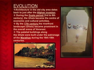
- 22. EVOLUTION Architecture in the old city area dates back to just after the Afghan invasion. During the Gupta period (3rd to 6th century), the Ghats became the centre of economic and cultural activities. By the 17th century the riverfront landscape (Ghats) became prominent in the overall arena of Varanasi. The palatial buildings along the Ghats were built under the patronage of the Marathas during the 18th-19th centuries. Even in 19th-20th centuries, many Ghats were reconstructed, renamed and reshaped.
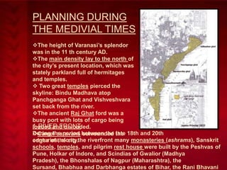
- 23. PLANNING DURING THE MEDIVIAL TIMES The height of Varanasi’s splendor was in the 11 th century AD. The main density lay to the north of the city’s present location, which was stately parkland full of hermitages and temples. Two great temples pierced the skyline: Bindu Madhava atop Panchganga Ghat and Vishveshvara set back from the river. The ancient Raj Ghat ford was a busy port with lots of cargo being 1-RIVER FRONT loaded and unloaded. During the period surrounded late Camel caravans between the the 18th and 20th centuries, along edges of the city.the riverfront many monasteries (ashrams), Sanskrit schools, temples, and pilgrim rest house were built by the Peshvas of Pune, Holkar of Indore, and Scindias of Gwalior (Madhya Pradesh), the Bhonshalas of Nagpur (Maharashtra), the Sursand, Bhabhua and Darbhanga estates of Bihar, the Rani Bhavani
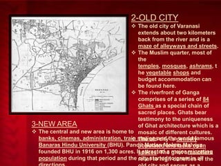
- 24. 2-OLD CITY The old city of Varanasi extends about two kilometers back from the river and is a maze of alleyways and streets. The Muslim quarter, most of the temples, mosques, ashrams, t he vegetable shops and budget accommodation can be found here. The riverfront of Ganga comprises of a series of 84 Ghats as a special chain of sacred places. Ghats bear testimony to the uniqueness 3-NEW AREA of Ghat architecture which is a The central and new area is home to mosaic of different cultures. banks, cinemas, administration, train station and thedensely The old city is world famous Banaras Hindu University (BHU). Pandit Madan Mohan Malviya populated and lacks open founded BHU in 1916 on 1,300 acres. It attracted a ghat area offers spaces. The major migrating population during that period and the relief to high densities all the city started to grow in of
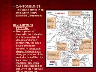
- 25. 4-CANTONEMNET The British stayed in an area, which is now called the Cantonment. DEVELOPMENT PATTERN: Over a period of time, with the inclusion of a large number of villages and urban settlements, the city's development has resulted in irregularly shaped built-up areas along peripheries of the central areas of the city. As a result the municipal city limits have been extended as and when the need was
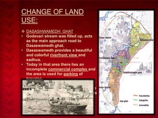
- 26. CHANGE OF LAND USE: DASASHWAMEDH GHAT • Godavari stream was filled up, acts as the main approach road to Dasaswamedh ghat. • Dasaswamedh provides a beautiful and colorful riverfront view and sadhus. • Today in that area there lies an incomplete commercial complex and the area is used for parking of bicycles. • The vegetable market is still there and it has now taken the place on the road. The skyline of the ghat area has drastically changed. • Sewerage pumping stations have come up.
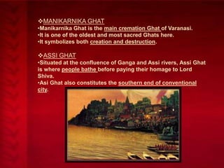
- 27. MANIKARNIKA GHAT •Manikarnika Ghat is the main cremation Ghat of Varanasi. •It is one of the oldest and most sacred Ghats here. •It symbolizes both creation and destruction. ASSI GHAT •Situated at the confluence of Ganga and Assi rivers, Assi Ghat is where people bathe before paying their homage to Lord Shiva. •Asi Ghat also constitutes the southern end of conventional city.
- 28. GROWTH PATTERN: The green spaces are reduced considerately because of: • New construction over them • The trees have fallen due to aging and no new plantation has been done. • Built open spaces. • Due to high economic pressures the city’s open spaces are reduced considerable. Permeability to the city has reduced, either the street is closed or the street width has reduced which has led to: • Lack of open space • Unhygienic condition • Improper drainage • Increase of pressure on primary routes
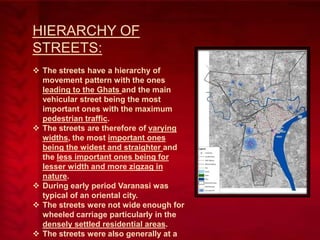
- 29. HIERARCHY OF STREETS: The streets have a hierarchy of movement pattern with the ones leading to the Ghats and the main vehicular street being the most important ones with the maximum pedestrian traffic. The streets are therefore of varying widths, the most important ones being the widest and straighter and the less important ones being for lesser width and more zigzag in nature. During early period Varanasi was typical of an oriental city. The streets were not wide enough for wheeled carriage particularly in the densely settled residential areas. The streets were also generally at a
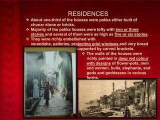
- 30. RESIDENCES About one-third of the houses were pakka either built of chunar stone or bricks. Majority of the pakka houses were lofty with two or three stories and several of them were as high as five or six stories. They were richly embellished with verandahs, galleries, projecting oriel windows and very broad and overhanging eaves supported by carved brackets. The walls of the houses were richly painted in deep red colour with designs of flower-pots, men and women, bulls, elephants, and gods and goddesses in various forms.
- 31. TAKSHILA
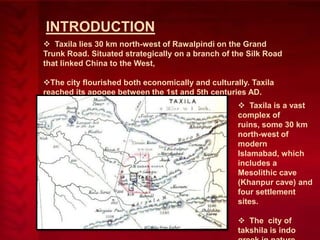
- 32. INTRODUCTION Taxila lies 30 km north-west of Rawalpindi on the Grand Trunk Road. Situated strategically on a branch of the Silk Road that linked China to the West, The city flourished both economically and culturally. Taxila reached its apogee between the 1st and 5th centuries AD. Taxila is a vast complex of ruins, some 30 km north-west of modern Islamabad, which includes a Mesolithic cave (Khanpur cave) and four settlement sites. The city of takshila is indo
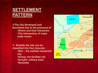
- 33. SETTLEMENT PATTERN The city developed and flourished due to the presence of •Rivers and their tributaries •The intersection of major trade routes Broadly the city can be classified into four mounds•Bhir – the earliest residential city •Sirkap- the fortified city •Sirsukh- military base •Saraidala
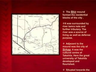
- 34. The Bhir mound formed the residential blocks of the city . It was surrounded by river tamra nala and further tributary. The river was a source of living as well as defense purpose. Adjacent to the mound was the city of Sirkap. It was the cultural centre of Takshila. Here the great university of Takshila developed and flourished. Situated towards the
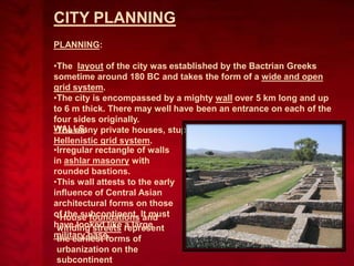
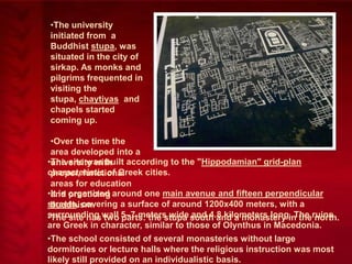
- 35. CITY PLANNING PLANNING: •The layout of the city was established by the Bactrian Greeks sometime around 180 BC and takes the form of a wide and open grid system. •The city is encompassed by a mighty wall over 5 km long and up to 6 m thick. There may well have been an entrance on each of the four sides originally. WALLS: private houses, stupas and temples are laid out on the •The many Hellenistic grid system. •Irregular rectangle of walls in ashlar masonry with rounded bastions. •This wall attests to the early influence of Central Asian architectural forms on those of the subcontinent. It must •House foundations and have looked like represent winding streets a large military base. the earliest forms of urbanization on the subcontinent
- 36. •The university initiated from a Buddhist stupa, was situated in the city of sirkap. As monks and pilgrims frequented in visiting the stupa, chaytiyas and chapels started coming up. •Over the time the area developed into a •The site was built according to the "Hippodamian" grid-plan university with characteristic of Greek cities. proper, functional areas for education •It is organized around one main avenue and fifteen perpendicular and practicing streets, covering a surface of around 1200x400 meters, with a buddhism. surrounding wall 5–7 meters wide south and a monastery in theruins •The site has two parts: the stupa and 4.8 kilometers long. The north. are Greek in character, similar to those of Olynthus in Macedonia. •The school consisted of several monasteries without large dormitories or lecture halls where the religious instruction was most likely still provided on an individualistic basis.
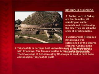
- 37. RELIGIOUS BUILDINGS: To the north of Sirkap are four temples, all standing on earlier mounds and overlooking the city. They are all in the style of Greek temples. Dharmarajika (Religious King) stupa was established by the Maurya emperor Ashoka in the Takshashila is perhaps best known because century BC around 3rd of its association with Chanakya. The famous treatise Arthashastra the Buddha. relics of (Sanskrit for The knowledge of Economics) by Chanakya, is said to have been composed in Takshashila itself.
- 38. NALANDA
- 39. INTRODUCTIO N The name Nalanda means ―the place that confers the lotus‖. Nalanda is traditionally believed to be the seat of Brahmanic learning till the beginning of the 5th century. It was however, the most renowned center of Buddhist learning in India
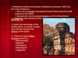
- 40. Historians believe the history of Nalanda university "falls into two main divisions— • first, one of growth, development and fruition from the sixth century to the ninth. • the second, one of gradual decline and final dissolution from the ninth century to the.‖ GROWTH Under the patronage of the Gupta rulers, a number of high rise viharas changed the skyline of the place. These five great Maha Viharas stood out: Vikramashila Nalanda Somapura Odantapurā Jaggadala
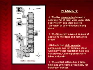
- 41. PLANNING: The five monasteries formed a network; "all of them were under state supervision" and there existed "a system of co-ordination among them. The University covered an area of about one mile long and half a mile broad. Nalanda had eight separate compounds and ten temples, along with many other meditation halls and classrooms. On the grounds were lakes and parks. The central college had 7 large halls and 300 rooms presumably for holding of classes.
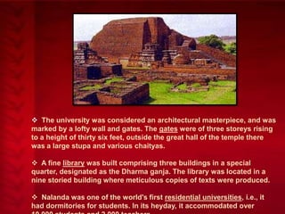
- 42. The university was considered an architectural masterpiece, and was marked by a lofty wall and gates. The gates were of three storeys rising to a height of thirty six feet, outside the great hall of the temple there was a large stupa and various chaityas. A fine library was built comprising three buildings in a special quarter, designated as the Dharma ganja. The library was located in a nine storied building where meticulous copies of texts were produced. Nalanda was one of the world's first residential universities, i.e., it had dormitories for students. In its heyday, it accommodated over
- 43. DECLINE Nalanda, along with many other Buddhist monasteries and temples, was sacked by Turko-Afghan Muslim invaders led by Bakhtiyar Khalji in the 12th century. This invasion marked the virtual end of Buddhist culture in India until the 1950s. Many historians also believe that destruction of Buddhist centers of higher learning at this time caused the abrupt demise of ancient Indian scientific thought in areas such as mathematics and medicine.
- 44. THANK YOU