
URDPFI - 2016
- 1. Submitted By :- Aryan Gupta B.Arch 7th Sem Subject :- Urban Designning
- 2. Planning is a continuous process & planning system should be such that it ensures continuity. Earlier town planning was a piecemeal process but after Independence the city planning experienced tremendous growth & challenges for resettlement due to political changes. Several resettlement, new Industrial base towns & urban centers were under process of planning & masters & town planners conclude that land use plans are needed to guide development of urban centers to promote orderly development & healthy living environment. For this purpose the ministry of Urban affairs & employment, governing of India organized a national workshop on master plan approach during February 24-25, 1995. The research study of this workshop awarded as UDPFI – Urban development plans formulation and implementation guidelines.
- 3. The Urban Development Plans Formulation & Implementation (UDPFI) Guidlines was formulated in 1996 following the recomendations of the National Workshop on Master Plan Approach. The first National level planning guidelines, referred to as ‘Urban Development Plans formulation and Implementation guidelines’ (UDPFI) were framed in 1996 by Institute of Town Planners, India. Since 1996, many changes have taken place in the field of urban development espically in view of emerging needs and requirments of urban settlments due to rapid popualtion growth and other reasons like globlizationand liberalization. Towns and cities are dynamic entities and are being subjected to unprecented changes in terms of requirments of infrastructure and other basic sevices or amenities. Besides, emerging issues like land use and transport integration within the TOD design and planning for green, compact and smart cities, along with building safer cities are at the riverfront. Comprehensive Moblity Plans (CMP) for Urban Transport, Service Level Benchmark, Disaster Management, Inclusive Planning, Sustainable Habitat, Enviromentally Sustainable Transport and Urban Reforms have added to the challenges, urging significant changes in the UDPFI Guidlines, 1996. Therefore to accommodate the wide change in urban development systems since 1996 the new ammendment was made : The Urban and Regional Devlopment Plans Formulation & Implementation (URDPFI)
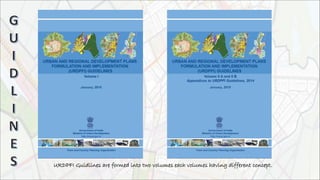
- 4. URDPFI Guidlines are formed into two volumes each volumes having different concept.
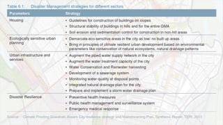
- 7. The study of UDPFI norms and standards is needed to evolve: System that is dynamic, flexible and efficient. Process that is less time consuming. Innovative ideas of land assembly and fiscal resource mobilization. Simple & effective form of laws, rules and regulations. Urban Development p and Plan Formulation and Implementation Guidelines were prepared in year 1996. Formulating Guidelines for preparation of spatial development plans and resource mobilization plans of small, medium and large sized urban centres. Promoting efficient implementation mechanisms and innovative techniques for promotion of planned spatioeconomic development of urban areas. Simplification of Town Planning laws and their amendments / restructuring. Primarily meant for the guidance of State Town and Country Planning Departments, Urban Development Authorities and Urban Local Bodies for preparation of Master Plans / Development Plans and formulating Norms / Standards thereof in order to ensure planned development of towns and cities.
- 8. Since 1996, many changes have taken place in the field of urban development especially in view of emerging needs / requirements of urban settlements due to rapid population growth and other reasons like globalization and liberalization. Towns and cities are dynamic entities and are subjected to unprecedented changes in terms of requirements of infrastructure and other basic services / amenities. • Integration of Landuse and transport at planning stage • Comprehensive Mobility Plans(CMP) for Urban Transport • Mixed Landuse concept • Service Level Benchmarks • Disaster Management • Inclusive Planning • Sustainable Habitat • Environmentally Sustainable Transport • Resource Mobilization • Streamlining the preparation of Master Plans • GIS Based Master Plans • Urban Reforms • Regulatory Framework for Town Planning Profession
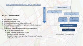
- 9. Chapter 1: INTRODUCTION The Planning Scenario Information for the users Revised Classification of Urban Settlements Revised Recommended Planning System with its Scope and purpose of various plans Sustainable Urban & Regional Development covering • State land utilisation policy, • Land transport integration, & TOD • Focus on regional planning, • Flexibility in plans and speeding the process of planning and implementation Relationship of Planning System
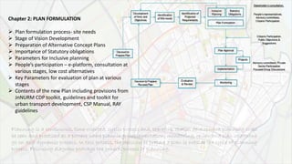
- 10. Chapter 2: PLAN FORMULATION Plan formulation process- site needs Stage of Vision Development Preparation of Alternative Concept Plans Importance of Statutory obligations Parameters for Inclusive planning People’s participation – e-platform, consultation at various stages, low cost alternatives Key Parameters for evaluation of plan at various stages Contents of the new Plan including provisions from JnNURM CDP toolkit, guidelines and toolkit for urban transport development, CSP Manual, RAY guidelines Planning is a continuous, time-oriented, cyclic process and, therefore, spatial development planning shall be seen and practiced as a process where planning, implementation, monitoring, review and plan updations go on as a dynamic process. In this process, the decision to prepare a plan is outside the cycle of planning process. Following diagram portrays the general process of planning.
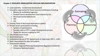
- 12. Chapter 3: RESOURCE MOBILISATION FOR PLAN IMPLEMENTATION Land assembly - Guided land development Innovative approaches for fiscal resource mobilisation including • Bilateral & multilateral agencies • Pooled Finance development fund scheme by GoI • Municipal bonds/debentures • PPP • FDI Existing Trend of Municipal expenditure pattern Private sector participation including • Systems of participation, • Possible roles of PPP in urban development process, • Toolkit for decision making for PPP City Infrastructure Fund Good Governance Institutional set up of TCP departments at State level, DPC’s , ULB’s Team requirement for plan formulation Institutional reforms • Urban- Regional Planning Development Regulatory Authority • Grievance Redressal system
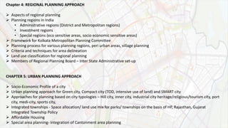
- 13. Chapter 4: REGIONAL PLANNING APPROACH Aspects of regional planning Planning regions in India • Administrative regions (District and Metropolitan regions) • Investment regions • Special regions (eco sensitive areas, socio economic sensitive areas) Framework for Kolkata Metropolitan Planning Committee Planning process for various planning regions, peri urban areas, village planning Criteria and techniques for area delineation Land use classification for regional planning Members of Regional Planning Board – Inter State Administrative set-up CHAPTER 5: URBAN PLANNING APPROACH Socio-Economic Profile of a city Urban planning approach for Green city, Compact city (TOD, intensive use of land) and SMART city Approaches for planning based on city typologies – Hill city, inner city, industrial city heritage/religious/tourism city, port city, medi-city, sports city, Integrated townships - Space allocation/ land use mix for parks/ townships on the basis of HP, Rajasthan, Gujarat Integrated Township Policy Affordable Housing Special area planning- integration of Cantonment area planning
- 14. Chapter 6: SUSTAINABILITY GUIDELINES Guidelines for Sustainability and Urban Development • Generic Energy Efficiency Guidelines- Energy efficiency • Urban Transport & infrastructure Impact of climate change (Green Building, Climate proofing, Resilience strategy) Bio diversity index and indicators Environment Policies and Statutory Obligations - • National Environment Policy 2006 • EIA Notification 2006 • Environment Protection Act 1986 • Forest Conservation Act 1980 • Strategic plan for new and renewable energy sector for the period 2011-17, MNRE Environment Guidelines for - • Environmental Guidelines for Industries • Guidelines for Rain Water Harvesting • Guidelines for Buffer Zones for various types of development • Environmental Guidelines for Planning Eco fragile zones • Eco fragile zones • CRZ Notification • Eco sensitive zones around protected areas; national parks and wildlife sanctuaries • Water bodies in urban areas, - Advisory Report for Conservation and Restoration of Water Bodies in Urban Areas’ & Repair, Renovation & Restoration (RRR) • National Environmental Policy 2006, MOEF - desert areas & wet lands, • Hilly areas
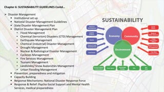
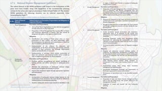
- 15. Chapter 6: SUSTAINABILITY GUIDELINES Contd… Disaster Management Institutional set up National Disaster Management Guidelines State Disaster Management Plan District Disaster Management Plan • Flood Management • Chemical (terrorism) Disasters (CTD) Management • Earthquake Management • Chemical (industrial) Disaster Management • Drought Management • Nuclear & Radiological Disaster Management • Cyclones Management • Fire Services Management • Tsunami Management • Landslides/ Snow Avalanches Management • Urban Flooding Management Prevention, preparedness and mitigation Capacity Building Response Mechanisms: National Disaster Response Force Response & Relief: Psycho-Social Support and Mental Health Services, medical preparedness
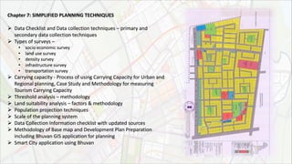
- 16. Chapter 7: SIMPLIFIED PLANNING TECHNIQUES Data Checklist and Data collection techniques – primary and secondary data collection techniques Types of surveys – • socio economic survey • land use survey • density survey • infrastructure survey • transportation survey Carrying capacity - Process of using Carrying Capacity for Urban and Regional planning, Case Study and Methodology for measuring Tourism Carrying Capacity Threshold analysis – methodology Land suitability analysis – factors & methodology Population projection techniques Scale of the planning system Data Collection Information checklist with updated sources Methodology of Base map and Development Plan Preparation including Bhuvan GIS application for planning Smart City application using Bhuvan
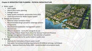
- 17. Chapter 8: INFRASTRUCTURE PLANNING ‐ PHYSICAL INFRASTRUCTURE Water supply • 24X7 supply • district area meter planning • leakage control • water quality standards- permissible limits (ISO) • Land requirement for Water Supply System Sewage and Sanitation • National Urban Sanitation Policy • Recommended design period for sewerage systems components • Decentralized wastewater management system – decision tree • Effluent standards - norms for sewage & its use • Recycling of Waste Water (Facts Sheet for Various Treatment Process) • Septage management (Guidelines for the selection of system) • Recommended Norms for public toilets in public area Drainage • Methods for Estimation of Storm water runoff • Rain water harvesting including requirements of artificial recharge, techniques Electricity - National Electricity Policy 2005 - recommended consumption levels
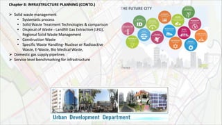
- 18. Chapter 8: INFRASTRUCTURE PLANNING (CONTD.) Solid waste management • Systematic process • Solid Waste Treatment Technologies & comparison • Disposal of Waste - Landfill Gas Extraction (LFG), Regional Solid Waste Management • Construction Waste • Specific Waste Handling- Nuclear or Radioactive Waste, E-Waste, Bio Medical Waste, Domestic gas supply pipelines Service level benchmarking for infrastructure
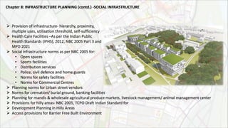
- 19. Provision of infrastructure- hierarchy, proximity, multiple uses, utilisation threshold, self-sufficiency Health Care Facilities –As per the Indian Public Health Standards (IPHS), 2012, NBC 2005 Part 3 and MPD 2021 Social infrastructure norms as per NBC 2005 for: • Open spaces • Sports facilities • Distribution services • Police, civil defence and home guards • Norms for safety facilities • Norms for Commercial Centres Planning norms for Urban street vendors Norms for cremation/ burial ground, banking facilities Planning for mandis & wholesale agricultural produce markets, livestock management/ animal management center Provisions for hilly areas- NBC 2005, TCPO Draft Indian Standard for Development Planning in Hilly Areas Access provisions for Barrier Free Built Environment Chapter 8: INFRASTRUCTURE PLANNING (contd.) ‐SOCIAL INFRASTRUCTURE
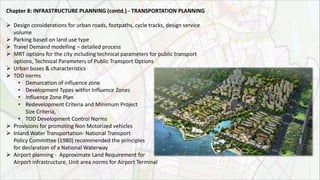
- 20. Chapter 8: INFRASTRUCTURE PLANNING (contd.) ‐ TRANSPORTATION PLANNING Design considerations for urban roads, footpaths, cycle tracks, design service volume Parking based on land use type Travel Demand modelling – detailed process MRT options for the city including technical parameters for public transport options, Technical Parameters of Public Transport Options Urban buses & characteristics TOD norms • Demarcation of influence zone • Development Types within Influence Zones • Influence Zone Plan • Redevelopment Criteria and Minimum Project Size Criteria, • TOD Development Control Norms Provisions for promoting Non Motorized vehicles Inland Water Transportation- National Transport Policy Committee (1980) recommended the principles for declaration of a National Waterway Airport planning - Approximate Land Requirement for Airport infrastructure, Unit area norms for Airport Terminal
- 21. Chapter 9: SIMPLIFIED DEVELOPMENT PROMOTION REGULATIONS Revised urban land use classification Revised plot requirement regulations in land use zones as per NBC (setbacks based on abutting road widths, rear and side setback, distance from electrical lines Norms for low income housing Revisions and inclusions in development promotion regulations for specific land use zones Special requirements for barrier free built environment for disabled and elderly persons Gender specific planning Building norms for Natural Habitat Form Based Codes
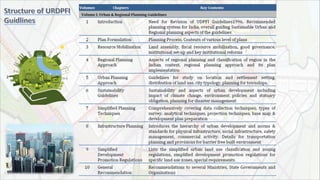
- 22. Chapter 1: Implications of 74th Constitution Amendment Act Provisions of 74th Constitution Amendment Act New Roles and Functions of State Town and Country Planning Department Status of the Provisions of 74th CAA on Urban Local Bodies Implications on Development Authorities/ Boards Chapter 2: The Right to Fair Compensation and Transparency in LAAR Act, 2013 Basis of the new Act Key Features Chapter 3: Model Regional and Town Planning and Development Law, 1985 Key features Suggested modifications in the law Chapter 4: Model Municipal Law , 2003 Key features Suggested changes in the Law Chapter 5: State Level Planning – Existing Legal Framework Key features of various state level legislations – Maharashtra, HP, TN, Gujarat, Karnataka, Bihar, Mizoram
- 23. Chapter 6: Legal Requirements for Industrial Development Industries (Development and Regulation) Act, 1951 Industrial Policy, 1991 Policy for Foreign Direct Investment Manufacturing Policy and Guidelines including National Manufacturing Policy 2011 NIMZ Guidelines SEZ Act 2005 Scheme for cluster development under Ministries Chapter 7: Other National Level – Legal Requirements National Heritage Conservation including AMASR Act 2010 National Environmental Legal Requirements, including EIA Notification 2006 Environment Protection Act 1986 Forest Conservation Act 1980 Coastal Regulation Zone, 2011 Eco-Sensitive Zones
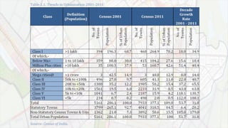
- 24. Globally, the more urbanised countries have higher levels of income and prosperity. Indian States also exhibit the same trend. At the same time, urbanisation is also perceived to be correlated with pollution, congestion and inferior quality of life. This would call for developing a paradigm of urban development that would bring in higher levels of prosperity, but without the concomitant negative effects. The URDPFI has attempted to develop such a framework. Population Trend : The Census 2011 and 2001 give useful indicators for the trends in urbanisation in India. The three urban agglomerations, viz. Greater Mumbai, Delhi and Kolkata, have crossed the 10 million mark in population, but with much reduced the rate of growth. The Million Plus population cities have shown a growth of over 48 per cent, but the number of such cities has gone up from 35 to 53 and five cities viz. Chennai, Bengaluru, Hyderabad, Ahmedabad and Pune have attained more than 50 lakh population. Nonstatutory towns : The trend of urbanisation is reflected remarkably in the size of towns that carry the growing urban population. As per Census‐ 2011, there are 7933 towns including 4041 Statutory towns and 3892 Census towns. It would be of great help to all if the Master Plan of the City/ Region incorporates the relevant features of all such sector specific plan. Also, the sector specific plans need to align with the framework of the overall Master Plan.
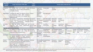
- 27. It consist of a. Perspective plan: 20-25years duration . Includes Maps & Diagrams . Stategovernment’s goal, policies, strategies of urban local authority regarding spatio-economic development. b. Development plan : Conceived within Frame work of approved Perspective plan. Medium Duration for 5 years. Proposals for socio-economic & spatial development of urban centers Including land use. c. Annual plan: Conceived within the frame work of Development plan. Details of new & ongoing projects for local authority to implement in financial year Necessary fiscal resources mobilization. d. Plan of Projects/schemes: •Conceived within the frame work of approved development Plan. •Includes detailed working layouts with cost of development, source of Finance & recovery instruments for Execution by a public or private agency.
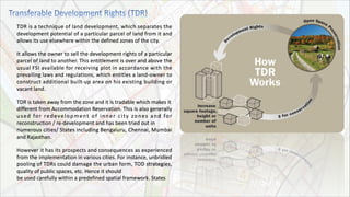
- 29. TDR is a technique of land development, which separates the development potential of a particular parcel of land from it and allows its use elsewhere within the defined zones of the city. It allows the owner to sell the development rights of a particular parcel of land to another. This entitlement is over and above the usual FSI available for receiving plot in accordance with the prevailing laws and regulations, which entitles a land-owner to construct additional built-up area on his existing building or vacant land. TDR is taken away from the zone and it is tradable which makes it different from Accommodation Reservation. This is also generally used for redevelopment of inner city zones and for reconstruction / re-development and has been tried out in numerous cities/ States including Bengaluru, Chennai, Mumbai and Rajasthan. However it has its prospects and consequences as experienced from the implementation in various cities. For instance, unbridled pooling of TDRs could damage the urban form, TOD strategies, quality of public spaces, etc. Hence it should be used carefully within a predefined spatial framework. States
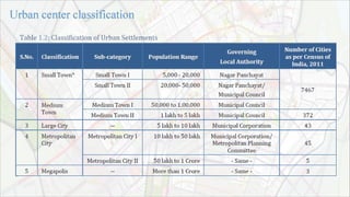
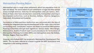
- 30. Metropolitan area is a large urban settlement, which has population from 10 lakh and above. The aerial extent of such settlements is huge and often spread across multiple districts. India has 53 metropolitan cities per Census, 2011. Many of these cities have already been covered by metropolitan planning or development authorities, such as Mumbai, Kolkata, Chennai, Bangalore, Hyderabad, Ahmedabad and Guwahati. Formulation of Metropolitans Authorities was conceived with the idea of initiating the integrated planning and development of the major cities and their surrounding areas. Constitution requires the States to constitute Metropolitan Planning Committees through State legislature. Various States- West Bengal, Maharashtra, Andhra Pradesh have issued procedures for formulation of Metropolitan Planning Committee (MPC) and metropolitan areas like Kolkata, Mumbai, Nagpur, Pune have MPCs. However, only Kolkata MPC has prepared a Metropolitan Development Plan (MDP). This has been referred as a lesson to guide the MPC formulation and integration in the existing scenario.
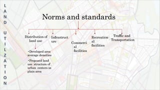
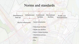
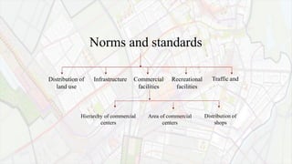
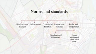
- 31. Norms and standards Distribution of land use Traffic and Transportation Infrastruct ure Commerci al facilities Recreation al facilities •Developed area average densities •Proposed land use structure of urban centers in plain area
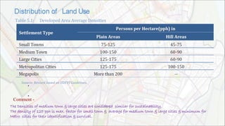
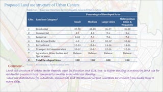
- 32. • • . Comment - The Densities of medium town & large cities are considered similar for sustainability. The density of 125 pph is max. factor for small town & average for medium town & large cities & minimum for Metro cities for their identification & survival.
- 33. Comment - Land use structure of urban center depends upon its function and size. Due to higher density in metros the land use for residential purpose is less compared to smaller areas with less density. Land use distribution for industrial, commercial and recreational purpose increases as we move from small town to metro cities.
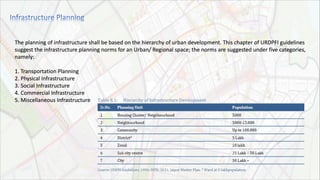
- 35. Physical infrastructure • Educational facilities • Health care facilities • Socio- Cultural facilities • Distribution services • Police • Fire Social infrastructure Commercial facilities Recreational facilities Infrastructure Distribution of land use Norms and standards Traffic and Transportation
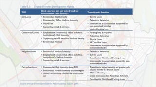
- 36. The planning of infrastructure shall be based on the hierarchy of urban development. This chapter of URDPFI guidelines suggest the infrastructure planning norms for an Urban/ Regional space; the norms are suggested under five categories, namely: 1. Transportation Planning 2. Physical Infrastructure 3. Social Infrastructure 4. Commercial Infrastructure 5. Miscellaneous Infrastructure
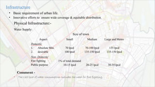
- 37. • • Basic requirement of urban life. Innovative efforts to ensure wide coverage & equitable distribution. Physical Infrastructure:- Water Supply: Size of town Aspect Small Medium Large and Metro Domestic 1. Absolute Min. 2. desirable 70 lpcd 100 lpcd 70-100 lpcd 135-150 lpcd 135 lpcd 135-150 lpcd Non- Domestic Fire fighting Public purpose 1% of total demand 10-15 lpcd 20-25 lpcd 30-35 lpcd • Comment - The 135 lpcd of water consumption Includes the need for fire fighting.
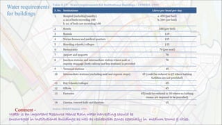
- 39. Comment - Water is an important Resource Hence Rain water harvesting should be encouraged in Institutional buildings as well as residential zones especially in medium towns & cities.
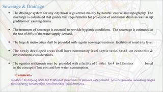
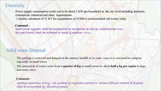
- 40. The drainage system for any city/town is governed mainly by natural course and topography. The discharge is calculated that guides the requirements for provision of additional drain as well as up gradation of existing drains. The treatment of sewerage is essential to provide hygienic conditions. The sewerage is estimated at the rate of 80% of the water supply demand. The large & metro cities shall be provided with regular sewerage treatment facilities at zonal/city level. The newly developed areas shall have community level septic tanks based on economic & environmental considerations. The squatter settlements may be provided with a facility of 1 toilet for 4 to 5 families based on the concept of low cost and low water consumption. Comment - In case of developing cities the Treatment plant shall be planned with possible future expansion including biogas plant ,energy conservation &environment considerations .
- 41. Power supply consumption works out to be about 2 KW per household at the city level including domestic, commercial, industrial and other requirements. 1 electric substation of 11 KV for a population of 15,000 is recommended for towns/ cities. Comment - Solar power System Shall be emphasized in residential as well as Institutional Areas. Bio-gas Plants Shall be Initiated in small & medium Towns.
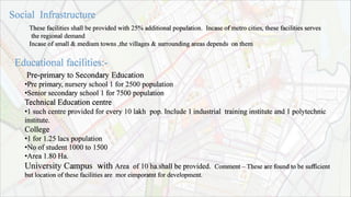
- 42. Pre-primary to Secondary Education •Pre primary, nursery school 1 for 2500 population •Senior secondary school 1 for 7500 population Technical Education centre •1 such centre provided for every 10 lakh pop. Include 1 industrial training institute and 1 polytechnic institute. College •1 for 1.25 lacs population •No of student 1000 to 1500 •Area 1.80 Ha. University Campus with Area of 10 ha.shall be provided. Comment – These are found to be sufficient but location of these facilities are mor eimporatnt for development. These facilities shall be provided with 25% additional population. Incase of metro cities, these facilities serves the regional demand Incase of small & medium towns ,the villages & surrounding areas depends on them
- 43. Comment - •The ratio of Dispensary is very less as due to polluted environment & life style of urban areas & accidents occurring everyday these needs to be improved/modified for metro cities.
- 44. Comment – •These need to be improved in Metro cities as Music, dance & drama Centers are Not only Cultural Oriented but it’s a part Of Industry. •These facilities can be clubbed with Commercial Activity.
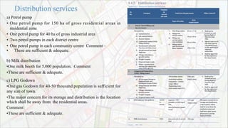
- 45. a) Petrol pump • One petrol pump for 150 ha of gross residential areas in residential zone • One petrol pump for 40 ha of gross industrial area • Two petrol pumps in each district centre • One petrol pump in each community centre Comment – • These are sufficient & adequate. b) Milk distribution •One milk booth for 5,000 population. Comment •These are sufficient & adequate. c) LPG Godown •One gas Godown for 40-50 thousand population is sufficient for any size of town. •The major concern for its storage and distribution is the location which shall be away from the residential areas. Comment •These are sufficient & adequate.
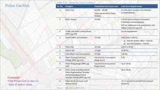
- 46. Comment – •The Police line is less in case of metro cities.
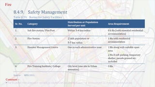
- 47. Fire Comment – •The disaster Management centers & rehabilitation shelters shall be encouraged in Social Infrastructure.
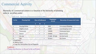
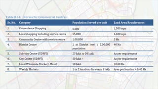
- 48. Area of commercial centers Distribution of shops Traffic and Commercial facilities Recreational facilities Infrastructure Distribution of land use Norms and standards Hierarchy of commercial centers
- 49. Hierarchy of commercial centers is a function of the hierarchy of planning units in an urban center Comment – •These distribution is found to be sufficient.
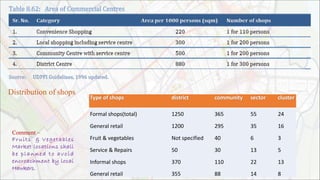
- 51. Formal shops(total) 1250 365 55 24 General retail 1200 295 35 16 Fruit & vegetables Not specified 40 6 3 Service & Repairs 50 30 13 5 Informal shops 370 110 22 13 General retail 355 88 14 8 Distribution of shops Comment – Fruits & Vegetables Market locations shall be planned to avoid encroachment by local Hawkers.
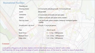
- 52. Planning unit Housing cluster sector community district Sub city centre Overall town/ city level 3-4 local parks and playgrounds 3-4 local park and playgrounds 2-3 community level park and open space 1 district level park and sports centre, maidan 1 city level park, sports complex, botanical /zoological garden , maidan 10 sq.m- 12 sq.m per person Type Small Town Medium Town Large cities Area in sq.mt. 1 - 1.2 ha. / 1000 persons 1.4 - 1.6 ha. / 1000 persons 1.2- 1.4 ha. /1000 persons Comment - Local parks ,Playgrounds & Open Spaces shall be distributed evenly in case of metro cities. The Proportion for large cities is average of small & medium town as the land is costlier in case of large cities.
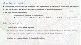
- 53. Cremation/ burial ground: Provision of at least 2 sites for 5 lakh population and to provide one electric crematorium for large size towns. Dhobi ghat: one site for 1 lakh population with appropriate arrangements for water and drainage facilities. Taxi stands/ Bus stops/ Rickshaw stands:- - These should not be located near the road intersections -The maximum distance of such facilities should not exceed 0.5 km from the farthest point in any residential area Communication- 10 lines per 100 population. The standards for mobile & telecommunication tower with their safe locations needs to be provided in Guidelines. In modern days the norms & standards for wi-fi system & internet shall be considered. Postal services- one post office for 10-15 thousand population.
- 54. Traffic and Transportation Commercial facilities Recreational facilities Infrastructure Distribution of land use Classification of Urban roads Design standards of Urban roads roads Norms and standards
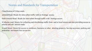
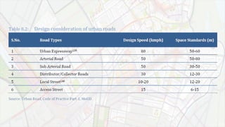
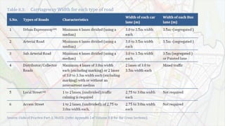
- 55. Classification of Urban roads: Arterial Road: Roads for intra-urban traffic with no frontage access. •Sub-Arterial Road: Roads for intra-urban through traffic with frontage access. •Collector road: Streets for collecting and distributing traffic from and to local streets and also providing access to arterial and sub arterial roads. •Local Street: Street for access to residence, business or other abutting property, having necessary parking and pedestrian movement free access too.
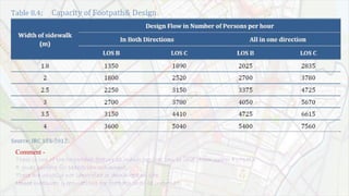
- 58. Comment - These is one of the Important feature as many services can be laid down under Footpath It gives surface for pedestrian movement. These are usually not identified or demarked on site, Hence measures & regulations for footpath shall be improved.
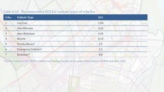
- 59. Car/taxi 1 Two wheeler 0.25 Auto rickshaw 0.50 Bicycle 0.10
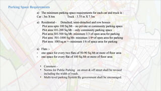
- 61. a) The minimum parking space requirements for each car and truck is : Car : 3m X 6m a) Residential - Truck : 3.75 m X 7.5m Detached, semi-detached and row houses Plot area upto 100 Sq.Mt – no private or community parking space Plot area:101-200 Sq.Mt – only community parking space Plot area:301-500 Sq.Mt- minimum 1/3 of open area for parking Plot area :501-1000 Sq.Mt- minimum 1/4th of open area for parking Plot area: 1001sq.m +- minimum 1/6 of space area for parking a) Flats :- - one space for every two flats of 50-90 Sq.Mt or more of floor area - one space for every flat of 100 Sq.Mt or more of floor area • • • Comment - Norms for Public Parking on street & off street shall be revised including the width of roads. Multi-level parking System By government shall be encouraged.
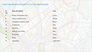
- 63. Sr. Zone description color No. 1 Primary Residential Zone yellow 2 Mixed residential Zone Orange 3 Unplanned residential Zone Brown 4 Commercial Blue 5 Industries Purple 6 Public & semi Public Red 7 Recreation Green 8 Roads Black 9 Agriculture Light Green
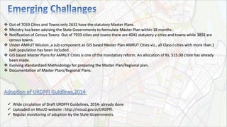
- 64. Out of 7033 Cities and Towns only 2632 have the statutory Master Plans. Ministry has been advising the State Governments to formulate Master Plan within 18 months . Notification of Census Towns- Out of 7933 cities and towns there are 4041 statutory y cities and towns while 3892 are census towns. Under AMRUT Mission ,a sub component as GIS based Master Plan AMRUT Cities viz., all Class I cities with more than 1 lakh population has been included. GIS based Master Plans for AMRUT Cities is one of the mandatory reform. An allocation of Rs. 515.00 crore has already been made. Evolving standardized Methodology for preparing the Master Plan/Regional plan. Documentation of Master Plans/Regional Plans. Wide circulation of Draft URDPFI Guidelines, 2014- already done Uploaded on MoUD website : http://moud.gov.in/URDPFI. Regular monitoring of adoption by the State Governments.
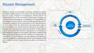
- 65. Disaster means a catastrophe, mishap, calamity or grave occurrence affecting any area from natural and manmade causes, or by accident or negligence, which results in substantial loss of life or human suffering or damage to, and destruction of property, or damage to, or degradation of environment and is of such a nature and magnitude as to be beyond the capacity of the community of the affected areas. As it is clear from the definition disaster may impact human habitat in a severe manner. Hence it is evident to manage these disasters at appropriate level so that impact can be minimised. The disaster management is continuous and integrated process of planning, organising, coordinating and implementing measures which are necessary or expedient for prevention, preparedness, mitigation, capacity building in pre disaster phase and response, relief and rehabilitation in post disaster phase as shown in Figure.
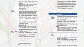
- 69. Section 31 of Disaster Management Act 2005 (DM Act), makes it mandatory to have a disaster management plan for every district. DDMP shall include Hazard Vulnerability Capacity and Risk Assessment (HVCRA), prevention, mitigation, preparedness measures, response plan and procedures. An indicative list with possible plan objectives is given below: i. To identify the areas vulnerable to major types of the hazards in the district. ii. To adopt proactive measures at district level by all the govt. departments to preventdisaster and mitigate its effects. iii. To define and assign the different tasks and responsibilities to stakeholders during the pre-disaster and post-disaster phases of the disaster. iv. To enhance disaster resilience of the people in the district by way of capacity building. v. Reduce the loss of public and private property, especially critical facilities and infrastructure, through proper planning. vi. Manage future development to mitigate the effect of natural hazards in the district. vii. To set up an Emergency Operations Centre at the District level to function effectively in search, rescue, response. viii. To develop the standardized mechanism to respond to disaster situation to manage the disaster efficiently.
- 71. • 2% in large cities & 5 Low Fsi In India the Fsi ranges between 1.2 to to 6 % in mega cities in special cases. • • The low value of fsi tends to more consumption of land & hence Shortage of land is faced for future development. These affects the lower & middle income group households due to Increased price of land. In Asian countries the fsi Practiced is between 5 to 15.Hence for affordability point of view, the fsi shall be increased to cater the demand of land for future needs. • • • Educational Facilities For safety Purpose the additional Space allocation for Peak Hour traffic in front of any school, colleges & other Institutions shall be provided. Primary & secondary schools to be used in Double shifts with Bigger intake for efficient use of land. Educational & institutional Zones must be crated in Master plan.
- 72. • Land Regulations Land regulations shall be revised to reduce the difference between what is allowed & what is Financially feasible. • These can be achieved by More compact cities, more efficient Land Use & Primary Infra structure. • Increase in consumption of fsi. • Decrease in Trip length due to compact cities. • Urban population density will likely to stay Constant due to efficient land use.
- 73. Arthur B. Gallion, Simon Eisner, (1986), “The Urban Pattern – city planning and design”, CBS publishers, New Delhi, India. Ar. Uttam K. Roy (2007), “Changing scenario & emerging planning norms for education infrastructures in planned township”, unpublished report, Institute of town planner, Chetan Vaidya, et al (2004), “Model Municipal law of India”, ITPI journal, D.S.Mesham (2004), “Master plan of auroville universal township”, ITPI journal, ITPI, 1996. Urban Development Plan Formulation and Implementation (UDPFI) Guidelines, Institute of Town Planners India, Ministry of Urban Affairs and Poverty Alleviation, Government of India, New Delhi.Sundar Burra & Sheela Patel (2001), “Norms & Standards In Urban Development: The Experience of an Urban Alliance In India” Roy Uttam Kumar (April 2004), “Development control Regulation”, journal of Indian institute of architects (JIIA)