As the City Rail Link works start to wrap up over the next year, focus is starting to shift to where next for improvement in the city centre and one of the areas to be focused on is the Downtown West area in conjunction with Pūmanawa Downtown West which is the redevelopment of the Downtown Carpark site.
Auckland Transport and the Council are putting together a programme to deliver these changes in order to achieve the vision from the City Centre Masterplan and a paper to AT’s board last week took a look at the council and AT would work together to deliver the programme but also just what is in the programme. It notes that the key components of it are:
- City Centre Bus Plan – Downtown Bus Improvements: Enhancing the bus network to ensure efficient public transport operations and improve overall accessibility in the downtown area.
- Improved bus facilities: New bus facilities and bus priority lanes on Lower Hobson Street, Sturdee Street, and Customs Street West (between Lower Hobson and Albert Street) to improve experience, reliability and reduce travel times.
- Removal of the Lower Hobson Street Flyover: Creating betterconnected, high-quality public spaces, improving public transport outcomes, and supporting broader urban regeneration goals.
- Urban Realm and Streetscape Enhancements: Upgrading streetscapes to foster a vibrant, people-friendly environment and strengthen connections across the downtown area.
- Changes to Private Vehicle Movements: Adjusting how private vehicles move through the area to prioritise access for local traffic, sustainable transport modes and a safer, more pedestrian-friendly environment.
- Integration with the Redevelopment of the Downtown Carpark Site: Supporting the transformation of the Downtown Carpark into a thriving mixed-use destination for residential, commercial, and retail activities.
Included in the paper was a memo to one of the council’s committees late last year that we missed that includes what some of the emerging plans are for the area are.
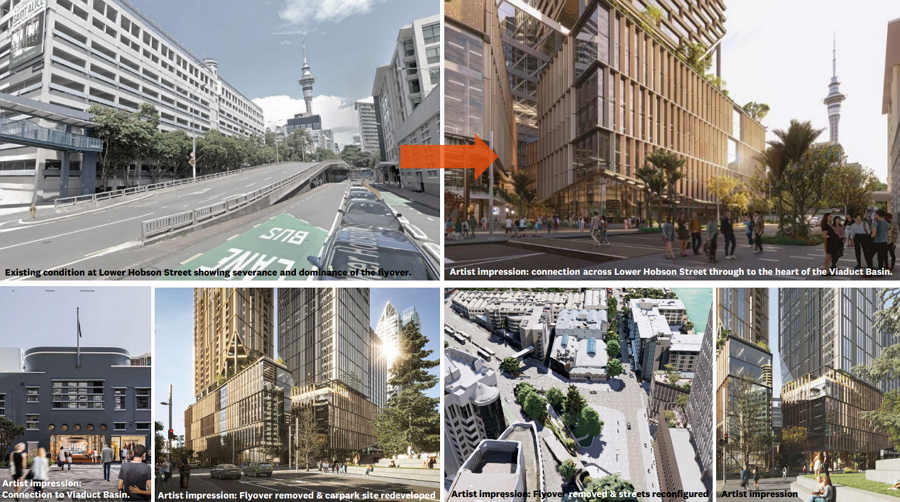
The biggest source of contention with the programme will undoubtedly be the removal of the Lower Hobson St Flyover. The memo highlights that removing it is key to unlocking improvements to public transport and to deliver urban realm benefits.
Removing the Lower Hobson Street flyover offers numerous benefits for the Downtown West precinct. It significantly enhances the public realm, creating a more open and inviting space for residents and visitors. At the same time, it facilitates better traffic circulation and supports more frequent and efficient bus services. The removal allows for the integration of bus layovers and bus priority lanes as part of the City Centre Bus Plan, ensuring smoother and faster transit operations. Additionally, it enables greater prioritisation of local and destination traffic, improving overall accessibility and connectivity within the city centre.
and specifically on the benefits to the City Centre Bus Plan it notes
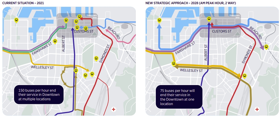
Transport modelling has confirmed that the removal of the Lower Hobson Street flyover is necessary for the City Centre Bus Plan to meet its objectives of supporting a more reliable, efficient, and customer-focused bus network. Removing the flyover will allow higher volumes of through-running Northern bus services to travel on Fanshawe Street. This change is expected to greatly reduce bus congestion, decreasing the number of buses on Sturdee Street from a forecasted 154 buses per hour to 80 buses per hour during the AM peak. Similarly, the number of buses on Customs Street West, between Lower Hobson Street and Albert Street, is projected to drop from 127 buses per hour to just 10 buses per hour during the same period.
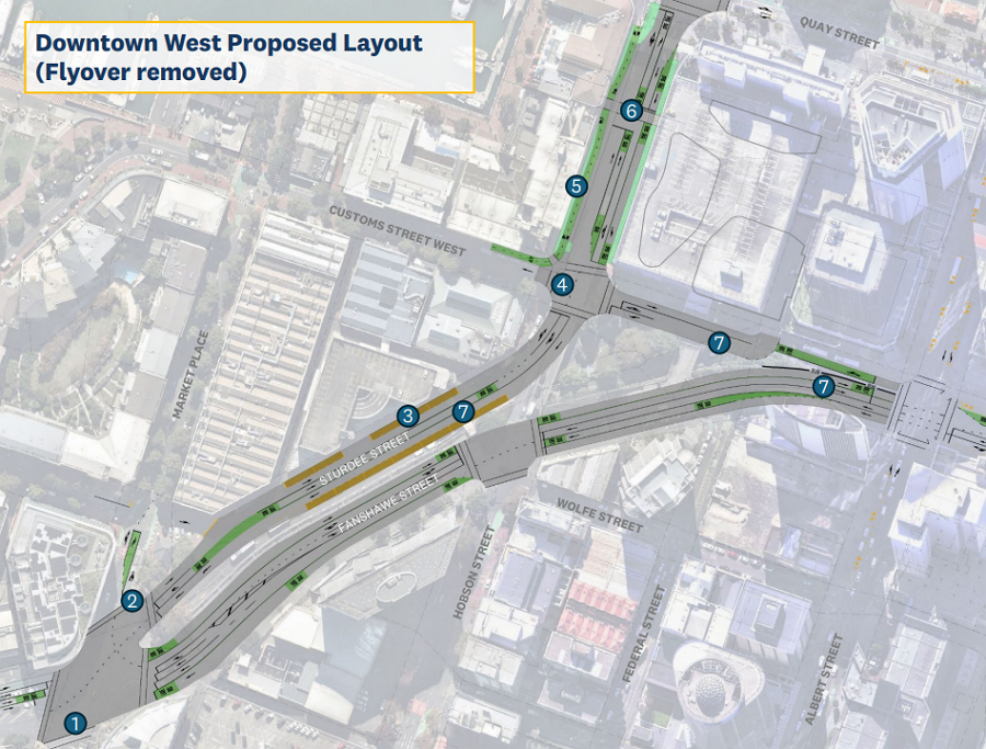
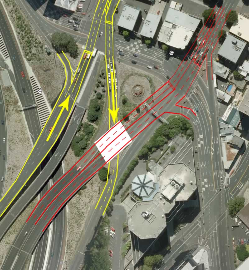
The removal of the flyover will likely see both Fanswhawe and Sturdee St two-wayed and with bus priority on both of them.
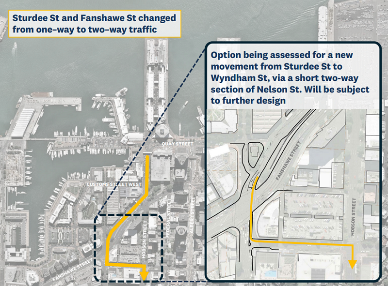
- Option being considered to convert a short section of Nelson St from one-way to two-way traffic movement to allow vehicles to access Wyndham St and Hobson St
- Bus right turn lane to enable buses travelling west on Sturdee St to turn around and head east on Sturdee St
- Bus layover space on both sides of Sturdee St
- Intersection reconfigured which frees up more road space for a potential future Sturdee St Public Space
- Existing cycleway integrated into upgrade of Lower Hobson St
- Lower Hobson St Flyover removed to free up space for improved bus priority and circulation, local vehicle access, loading and servicing and the ability to create more space for people
- Convert Sturdee St, a section of Customs St West and Fanshawe St between Federal St and Albert St from one-way to two-way traffic movement
As noted, they are considering converting a short section of Nelson St to two-way.
I wonder if that could be the start of eventually working towards two-waying these streets permanently. The trickiest part would be at the motorway end but this is an idea we suggested around 15 years ago for how the motorway ramps could be changed to support such an idea.
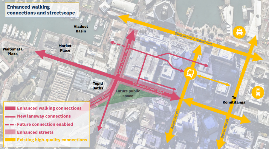
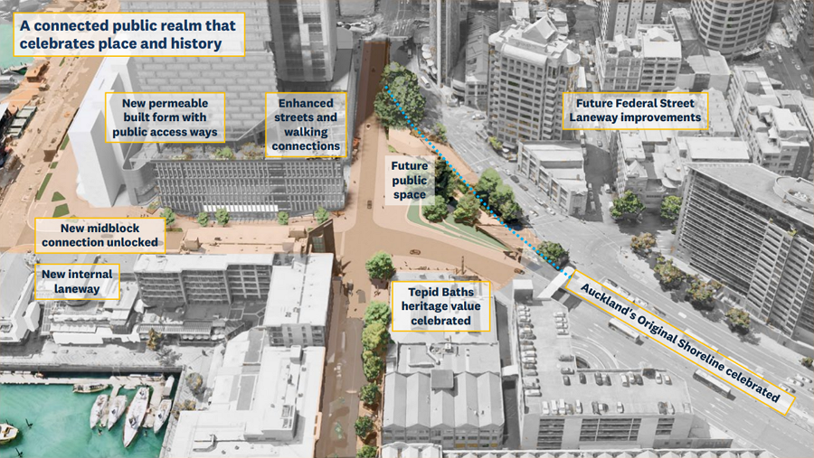
The proposed changes open a significant area of improvements for pedestrians in an area that is currently hostile and unattractive for walking. This will especially be the case in conjunction with the Pūmanawa Downtown West development which will include a number of public laneways that will connect through to Albert St and the rest of the downtown area.
As for the common refrain from people opposed that that it will impact traffic and cause congestion, not so.
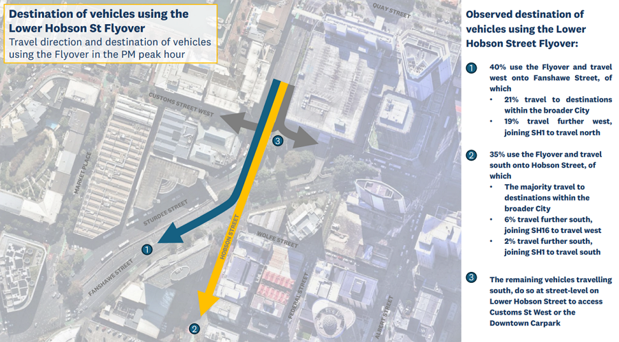
- We understand there are concerns around the impact to private vehicles of removing the flyover. Traffic using the Lower Hobson Street flyover has reduced by half since 2019. Observed effects from a temporary closure of the flyover in 2020, combined with transport modelling, strongly indicates that with the flyover removed traffic volumes can be balanced across the network with minimal impact, particularly to journey times on Quay and Customs Street.
- The transport modelling and data confirm that the network can perform and function effectively without the flyover. Traffic data reveals that only 35% of those using the flyover travel south onto Hobson Street, with only 8% using this route to access the southern and western motorway system. The majority are travelling to destinations within the broader city. Vehicles who previously used the flyover to gain access to Fanshawe St to head west will be able to do so via a 2-way Sturdee St. To further mitigate the impacts to the limited number of vehicles who use the flyover to travel south on Hobson St to gain access to the southern and western motorway, an option is being investigated to convert a short section of Nelson Street from one-way to twoway traffic movement to allow vehicles travelling west on Sturdee Street to access Wyndham Street and Hobson Street
 Many parts of this programme, like the flyover removal, are currently unfunded but information like this will be critical for building the case and winning support for it.
This post, like all our work, is brought to you by the Greater Auckland crew and made possible by generous donations from our readers and fans. If you’d like to support our work, you can join our circle of supporters here, or support us on Substack!


 Processing...
Hard to follow all those changes, and highly sceptical of “bus priority” with two way roads meaning presumably more intersection stops to allow all the traffic movements. Those intersections, of which there seem to be a lot now, get blocked by single cars.
Current northern buses coming in at peak get clogged up with all of the vehicle movements around Customs, and the various car parks, etc. Obviously with downtown gone this will reduce but it should just be continuous 24/7 busways, on a way type route.
How do buses leave downtown with flyover removed?
The plan above shows continuous bus lanes in both directions on Fanshawe Street at the upper level, presumably these with be 24-7.
So it looks like the northern buses will skip Sturdee and the first part of customs entirely. If you look at that snip from teh city centre bus plan, the northern buses won’t be on albert or going around Quay street on the way out of downtown, they’ll go straight from Customs Street to Fanshawe Street. That sounds way more direct and reliable.
Good plan IMHO
OK thanks. So the lower Albert bus interchange is no longer? Where do these buses start/end – through Customs to where?
Lower Albert St would still be used by Western buses, and (according the city centre bus plan) by Central Isthmus buses from Symonds Street (many of which would change from running through Midtown to instead running the full length of Symonds and down Anzac Ave).
Northern buses would head to a termination point somewhere around the bottom of Parnell Rise. I could be wrong but I’m sure I read they may have wanted to use the loop at the old railway station but the owners said no.
That sounds less than ideal with the number of intersections between lower Parnell and the main bus stops of lower Albert then the stops on Fanshawe.
Unless there is some actual bus priority (which won’t happen) plus closing off turning cars from the side, etc this will be chaotic for buses even being able to meet their start time I would have thought.
There would need to be serious changes to all of that Customs/beach/anzac etc area
North shore buses won’t use the bus stops on lower Albert street, they’ll stop on Customs street and run straight along Customs to Fanshawe without turning. The Albert Street buses and the ones coming down Anzac will end at lower albert street instead.
Yes, the plans linked above show major improvements to bus lanes.
This is the critical moment to incorporate proper bike infrastructure in all these roads. Fanshawe St needs a diet, and to become a boulevard.
The TERP’s instruction is to “supercharge” cycling, and to invest in the mode that needs the most increase in modeshare (cycling).
This is possible while giving bus priority too, but only if much more space is taken from the major space hog.
Whether or not anything can be done with Fanshawe Street as a through route, a mid-block crossing between Alert and Hobson will allow Federal Street to get its boost as a laneway, connecting down the wall to the new public space, Te Pumanawa and Lower Albert cycleway.
Albert – I wasn’t Alert when I posted.
Yes, but AT should be providing more fundamental safety, via reducing the number of lanes.
My elderly relative who lives in the Viaduct always takes the bus past her stop on Fanshawe St (heading west) so she can transfer to a bus coming the other way in a safe place (Wynyard or Victoria Park Market, depending on bus). She does this in preference to crossing Fanshawe at any of its crossings because they are unsafe.
Auckland Council? Do what it says it will do? That seems unlikely.
‘We are at a point now where cycling will be embedded across all teams and work within AT and incorporated as a matter of course into all designs and thinking’. We heard this time and time again in 2018/19 as justification for dismantling AT’s walking and cycling team. Here we are 6 years later, and these designs are still being put forth with cycling completely absent…what a farce.
One question I have is whether Auckland’s CBD’s development potential is limited and we have been cannibalising some older established commercial spaces when we go for one new development.
For example, in the 1980s we could argue that the main Queen Street and Albert Street. Then in the very early 90s we focused on the “upper” part of Queen Street at plots near Aotea Centre and the Town Hall. A few years later the focus turned to the Viaduct Harbour, 10 years later it was the Wynyard Quarter and Britomart’s turns. But as we moved on, first Queen Street and Albert Street became tired such as the original Chase Plaza, and now the early gentrified 1990s parts such as the Atrium and the Sky World has become very tired. Will the 2000’s developments like the Viaduct Harbour become the next casualty?
I know the older generation often argue that Auckland’s commercial activity potentials are limited and Auckland’s CBD is already beyond what New Zealand as a whole can reasonably sustain in commercial trades, and as you open up developments in one part of the CBD, the businesses move to the new posh part and pushing the older developed corners down the food chain in terms of being hip. As commercial trade dries up, owners put in far less money in their upkeep. You see it with say, Atrium and the Sky World – both places were very hip in the mid 90s (or the late 90s in Sky World’s case, but they are both run down cheapish corners now). So you often see cynical comments from older people on websites or social media, and they are highly sceptical or even critical towards these developments.
Do you think perhaps these old people have a point? How do we stop such cycle in its track? How can we grow Auckland’s commercial trades in the CBD with sustainable, high value, activities that can over time bring in more needs for CBD types of spaces?
Thanks.
Having more people living in the city centre seems like a good way to raise the volume of commercial activity.
Being able to live, work and play in a wildly diverse few square kilometers would appeal to many.
Although rent and property prices are likely to be premium, the overall cost of accommodation and transport is balanced by being able to live car-lite or car free.
When an area becomes the forgotten child in favour of a new one, it would be good to see commercial buildings out of favour be converted to apartments. Gets more people back into the area to revitalise it.
I just don’t know what spur or incentive is needed to make that happen more.
Conversions of commercial to residential and not easy and not cheap – mainly this relates to the building regulations around fire prevention, containment and evacuation. Commercial and residential buildings are fundamentally designed differently in their fit out to address these, including things like sprinklers, fire proofing and location of stairwells etc. Conversion isn’t cheap, and it can be problematic to retrofit existing buildings to comply, which is why we don’t have more of it here in NZ.
Interesting topic. I think the other replies around having more people living in the area are key and then that would enable the different locations to have some of their own flavour. In other cities places are known for the Youth hangout areas, foodie street, arts etc etc. We just tend to move the same shops around and around.
I’ve always thought a downtown sports center would go well, at all hours.
Padle, pickleball, tennis, basketball, futsal. People can hire courts, as could sports, schools or business groups booking out the facility for events. Leagues could utilise it after work etc.
Would mean people milling about there all through the day and night, bringing f&b, sports retail, etc into the area.
I love the idea though it probably would have to be financed/supported by council as you likely could not get the revenue in just from court hire. However, I would see that as a service (not a cost) and it would likely raise revenue of nearby businesses and quality of life for a lot of people living and working in the CBD.
The University of Auckland recently opened its new sports and rec center and that is always packed with people, so having something for the more general public would be great.
Totally, London has a great system with hiring the cage courts for football, etc via website/app.
From my readings, this has always been the way of cities. Rundown areas become cheaper, attracting the creative sector and party people who reinvigorate the district, which then becomes attractive to the moneyed sector, and thus development is then encouraged.
The commercial potential of the city doesn’t have a limit-it will expand as it needs. This is the way. Why would you think there is a limit, just because the rest of the country is not large?
Yes, probably needs to be provided by AC. But they build and provide facilities for communities all over Auckland. Why not the 30k+ people living in the city center?
Would also get additional (targeted?) Rates from new businesses in the surrounds.
I think there are a couple of things here.
1. City Centre employment has continued to grow and so has Auckland in general so I don’t think it’s cannibalising growth from other areas, just changing the types and makeup of employment. But this is normal.
2. There’s been an expectation for over a century that the city centre would re-orient east/west along the harbour, it’s one of the reasons the railway station was moved to The Strand way back then. It’s happening now though.
3. That shift opens up new opportunities, especially for other businesses and as noted above, apartment conversions.
4. CRL will provide a lot more value to being in mid-town as it will be much easier to get to. One CRL and other mid-town works complete it should help address a lot of this.
5. I don’t agree that the city is beyond what NZ can sustain but also as Auckland continues to grow, and I’d argue we should encourage more growth here, it will create additional new demand.
Yee, More living in city centre, general population growth and CRL should see the city centre prosper.
Why not make Hobson and Nelson Street two way up to Victoria Street? Here’s a plan I did earlier https://natlib.govt.nz/records/23153817
You jest, but yes if we could just admit that turning the whole city centre into motorway offramp couplets was a bad idea we could go back to the way it was. The fact that first block of Hobson is five lanes wide in one direction despite being fed by only two lanes and a turn pocket underlines how ideological it was. It’s not even good traffic engineering.
The fact the downtown carpark is going should put an end to that 1960s fever dream and they can go back to being normal streets.
still unconvinced how the proposed off-street downtown bus terminal that AT seems to want in the base of the new Downtown towers would fit into the City Centre bus plan. this plan doesn’t seem to have much of a thought spared for how that would work either.
The bus terminal inside the site was dropped from being a requirement which is one of the reasons they also need the space the flyover currently uses
It doesn’t, it was dropped. Turns out an off street bus station takes up a massive amount of space and just means people and buses need to go further to get to it. The entire ground floor level of the carpark site is less than half the size of the manukau bus station for example, when it would need to have three or four times the capacity. If you needed space for the buses to all turn around inside the carpark site, the station would have less stops than the bus block on lower albert street, let alone be able to do all the others.
Having the stops on the street means people get on and off closer to where they are going and the buses don’t need to drive round and round the block to get in and out of a station.
Exciting to see this development progress and the vision of the original City Centre Masterplan. Thank goodness Mike Lee, C&R members of the local board, the saboteurs, Krukziener etc failed to stop the sale of the Downtown Carpark.
AT also came close to sabotaging the whole project by recommending (in 2020) council sign off on a huge number of public car parks as a requirement of the development.
Very unconvinced at the “future public space” on the 3D illustration – sitting opposite the Tepid Baths. Anyone ever going to sit there, in the shade of a tall building, between 2 almost motorways? No, come on, be truthful. It will be as uninhabited as a rock in the Hauraki Gulf, only a lot less desirable. Who is ever going to walk out over to there? And How? And Why? Its going to be a non-happening thing. Kill it now.
That’s what everyone said about Te Komititanga too if you remember. Let be real, it’s a wind tunnel in the shadow of tall buildings, nobody will go there etc etc. Said the same thing about the public space in Britomart too. Oh and the Quay Street upgrade, that was going to be a windswept and exposed wasteland remember. Same with the Wynyard quarter park, nobody was ever going to trudge out there in the rain and wind. Oh and Freyburg place, so few people were going to sit in that wind tunnel that we had to keep a road across the front. Oooh and the Victoria linear park, who wants to sit on a footpath next to a main road under some skycrapers right? Same with fort street shared space, nobody’s going to sit out on that grungy street in the shadow of buildings to eat their lunch of have a drink are they?
And yet…
Yeah crazy idea having public space near tall buildings, good job they don’t do anything like that in other cities.
> Who is ever going to walk out over to there?
All the current people (and new people) who live around there. If you make the space accessible (ped crossings that don’t require you to apply two hours in advance are good).
> in the shade of a tall building,
As others said, don’t underestimate city life. Plus, the removal of the flyover and the presence of a low-slung heritage building (Tepid Baths) means that the space will actually get a good amount of afternoon sun compared to what it has now, I think.
To be fair, I thought the same thing when I looked at that particular space.
Its marooned in between some pretty busy traffic routes. The colouring of the streets on the left make it looked like it might be a shared space with slow running vehicles, but I don’t think that’s the case, is it.
The shading of buildings I don’t think is an issue but comparing it to a public plaza like Te Komititanga is stretching it a bit.
I actually thought it was the perfect place for public toilets…
But hey – I’ll never say no to more green spaces, so hopefully I’m wrong.
Could also be a place to put an ice cream cart, a coffee cart and a few benches and instantly give people a reason to hang out.
I think you’re underestimating the change proposed there, and maybe the topography.
The traffic wasteland that is Sturdee St becomes much more like local streets, think customs street west or Market Place.
The Hobson flyover goes and Lower Hobson will be broad with buses, yes, but still a ‘normal’ city street far better than the dead zone it is today. Think the part of QUay Street by the new waterfront space that has the buses on it.
The main traffic corridor will be above and behind the public space on Fanshawe Street. The space itself is shown a terracing, north facing with a view line down Hobson to the waterfront. It’ll catch a bit of sun.
I think one of the best things is you’ll have a clear walking path down the terrace between the upper level of hobson and Federal street and the waterfront area. Currently that’s almost impossible.
Agree, this should be one of the better areas of our city, right by the water/viaduct and now close to all of the improvements to Quay st, commercial bay. etc.
Calming all the traffic down will be key and removing the carpark is the main issue.
Still slightly sceptical of driveways and car movements given the huge development proposed and the car parks associated with that but hopefully it is a good plan.
It would be great if we could get away from the whole senior leader/partner of major firm needs a carpark in the office building. And these leaders actually led from the front by using PT.
I’m hoping this work won’t start until the CRL is actually operating? At present I don’t have a bus that goes to downtown and as an older female with a disability I certainly don’t feel safe walking to/from Wellesley Street (by Sky City convention centre) at night. While most trips I make into the city are by bus, if coming in very early or in the evening I currently drive and park at Downtown.
FYI if you’re not on the train or a downtown bus route, you’ll be able to get any bus on Albert Street or Queen Street to travel between wellesley and downtown. They each run every couple of minutes even late at night or very early.
From what I see on the renders there will be large areas of open space with little shelter from inclement weather. Some scenes show sun drenched spaces where there is little to none now due to surrounding buildings. Must be being provided by the magic of the proposers. I also note the moving of transit to the streets again. No doubt with the same lack of cover as exists in Lower Albert St. To me these are clearly designs created by non PT users.
The renders show broad verandahs and arcades in the new building, unlike the existing carpark which has nothing for shelter. Big win.
It looks like most of this is focussed on Customs street for bus stops, which has big awnings for rain cover. I loved it when the NEX was on customs because it saved a walk over the road and up a block.
Not sure why you mean by moving of transit to the streets again, where is the transit now? Where would you have buses run if not on the street?
It is just a pity that AC got such a poor deal on the Downtown Carpark sale and now need to fund the removal of the ramp to support the private developer’s plans.
Incompetence? Or corruption?
Precinct do this for a living vs AC (incompetence all round?)
Cycle facilities are absent from this design. Were they just forgotten? Especially connecting the existing protected contraflow lane at the north end of Federal St to…anywhere.
Good development! Saying as someone who drives regularly and an urbanist I support all this wholeheartedly. Some naysayers are saying that “Australia is better”. But Australian cities are already saying this. They will turn around and say “Oh but Australia is different”. So what gives? Do it.
Looks like a pretty good plan.
It should start as soon as possible. Waiting until something else is finished just pushes everything out.
I mean there are loads of parking buildings in the CBD for users who do not want to bus.
Let’s hope the mayor keeps his beak out of this.