Please see link to consultation on proposed changes to SH1. The pine hill changes for cyclists and pedestrians are unclear at this stage. The Duke street changes seem to be an improvement and there are significant changes at Queens Garden. Please provide your feedback via the online survey by 23rd of May. It would be good to see a discussion to share our ideas.
I see they still are fudging the cycle path northbound through the junction. We have discussed keeping the cyclists on the footpath on the right up to the new world gardens junction (and making that a barnes dance) but I don’t see anything about mentioned and I assume cyclists are meant to cross over just at the place that drivers are concentrating on crossing sh1, and then take their chances in a lane beside parked cars ![]()
Its quite a dangerous intersection, but seems from their proposed changes they are not really keen on making it safer for people on bikes / people walking;
“The SH1 proposed improvements are part of a business case which identifies ways to improve accessibility, supports new developments like the new Dunedin Hospital, while maintaining efficient traffic flow, and reduces risk for road users and pedestrians,” says Mr Duncan.
Keeping traffic flow and making it safer for pedestrians / people on bikes, doesnt really work together. Ideally I would see traffic lights here as a start, so its safe to cross for everyone, but not sure they are too keen on that because of the focus on carflow.
A tunnel for cars or dutch roundabout would be best, but that cost a lot of money unfortunately.
Hi all
I’m not from Dunedin, but I had a look at the move of the current cycle “lane” heading northwards past Queens Garden - WK proposing to shift that space to a ‘shared space’.
Then I read that the new ACC building will bring in 800 people into the area, which invariably means increased pedestrians, and increased risk for both cyclists and pedestrians.
I don’t think it sensible to remove an existing cycle lane (in effect grab that space) and stick cyclists on the footpath.
It would be better to take the space that the cycle lane is using, and create a separated cycle lane next to the footpath, and separated with concrete cameo cremes, which is the gold standard we need, particularly for anything next to SH1.
Hope this makes sense.
Christopher.
Secretary, CAN.
Unfortunately the space the cycle lane is currently in isn’t wide enough for a separated cycle lane with those cameo cremes. It would mean taking space from either the parking, the footpath or the reserve
The former is apparently unthinkable, the latter is feasible, but I’m guessing just painting a cycleway icon on the not very well used footpath is cheapest.
Controversial opinion I know, but I prefer the current set-up with paint and hit sticks. I usually merge right across the two lanes of traffic at some stage in that block where the close together traffic lights usually slow down the traffic between the duke of Wellington pub and Stuart street. So I’m annoyed they are talking about changing that. Crossing over while the one way is still on Cumberland Street is usually a dicier proposition.
Of course I can always dismount and wait for the pedestrian lights as per the official advice, but I strongly resent that
1 Like
Thanks for your comments.
What’s your perspective on the opening of the ACC building that will have 800 workers? Will that increase pedestrian/cyclist movements in the area?
I have to say, gosh you have chutzpah! Cycling in the middle of the traffic would really test me!
I have an e-bike, which really helps match traffic speed when it’s going about 30 - 35. I feel a whole lot safer and more visible in the main traffic lane between Queens Gardens and the Leviathan. In the cycle lane I’ve had a few near misses both with traffic turning into the one way north from the one way south (including professional bus drivers) and with people turning into the parking lot just north of the Leviathan. I think you can still see my rubber from one of those. Proud of myself for stopping just short of the driver’s door without losing my balance- I’m not a stunt rider.
In terms of increased foot traffic it’ll probably mostly be on the ACC side of the road. The parks in the Queens garden area people would be using that footpath to access are usually full with medium - long term parkers anyway. Maybe a few more would be changing their destination. I think you are right that it will be more dangerous for pedestrians because some cyclists always expect to be able to go full tilt on shared paths, and that bothers me, regardless of whether the number of pedestrians on the path increases
I often cycle along the cameo’s I feel safer there. A plastic hit stick isn’t going to stop a big car coming into the bike lane, concrete seperation does.
Ideally it would be great if what now is being used for parking can be used for a bike lane. Shared paths means conflicts with pedestrians and isn’t ideal either (especially if it’s busy).
It would be great to see if there is some traffic data along this bike lane to actually see how busy it is.
Europe has standards when a shared path should be seperated looking at the amount of traffic.
Also how much space is currently dedicated to cars vs bikes / pedestrians. It’s good to ask that question making them realise that majority of space is dedicated to cars even without the parking.![]()
I generally feel safer in the separated cycle lanes, but that little section with 2 dodgy vehicle crossings, not particularly so
Wrt the Queens Garden intersection, it seems a mistake to alter it. However, if they are going to, the crossing at queens garden should be a Barnes Crossing.
1 Like
Wrt the north Dunedin intersection, the most effective solution would be a bridge over for the southbound SH1 traffic, with the northbound NE Valley traffic passing under. Still doesnt solve the NE valley cyclists getting from the right to the left, which probably requires a traffic light crossing.
Great to have all the comments, suggestions. I think the existing cycle lane “protected” by the wands, sandwiched between two lanes of traffic including large trucks is only suitable for confident cyclists and agree that it should be changed. I also think a shared path is a cop out and they should use the space created to put in seperated cycle lane. It is worth noting the plan to encourage more cyclists down Vogel street as a “quite street”. THis is a great space to bike down and the more people who use it the better it will be. Vogel street will then link into queens garden. I would like to know how people will get to the ACC building by bike with these changes and also how people will link in to the octagon (some people go up dowling and burlington.) access to these streets needs to be maintained.
1 Like
From NZTA:
Feedback sought on proposed improvements to Dunedin’s SH1 one-way system
NZ Transport Agency Waka Kotahi (NZTA)’s plan to make the Dunedin SH1 one-way system easier to use, safer for everyone and more efficient takes its next step from today (Tuesday, 15 April). People’s feedback is welcome from Tuesday to Friday, 23 May.
Running between The Oval and the Pine Hill Road/Great King St intersection, SH1 on Cumberland and Castle Streets, is a key freight and commuter route linking the north and south sides of the city.
“In particular, NZTA wants to know what Dunedin people think of the preferred option for making the Pine Hill Road/SH1 and Great King St intersection safer and more functional for everyone,” says Ian Duncan, Acting Director of Regional Relationships for NZTA in Otago.
The intersection is a key part of the SH1 one-way system into and through Dunedin, close to the Botanic Gardens and the entrance to North East Valley.
-
NZTA is now keen to hear what people think of its preferred option for this intersection, with several other proposed safety improvements to the SH1 one-way system, to help guide the next steps for this option. Information on consultation and feedback here: https://www.nzta.govt.nz/projects/sh1-dunedin-improvements/
-
Link to the survey here: https://surveys.nzta.govt.nz/jfe/form/SV_3shv1Sw193rbmGW
“The SH1 proposed improvements are part of a business case which identifies ways to improve accessibility, supports new developments like the new Dunedin Hospital, while maintaining efficient traffic flow, and reduces risk for road users and pedestrians,” says Mr Duncan.
He notes the long-standing safety concerns with increased risk of crashes because of limited visibility and heavy vehicles descending a steep hill at the SH1/ Pine Hill Road/Great King Street intersection.
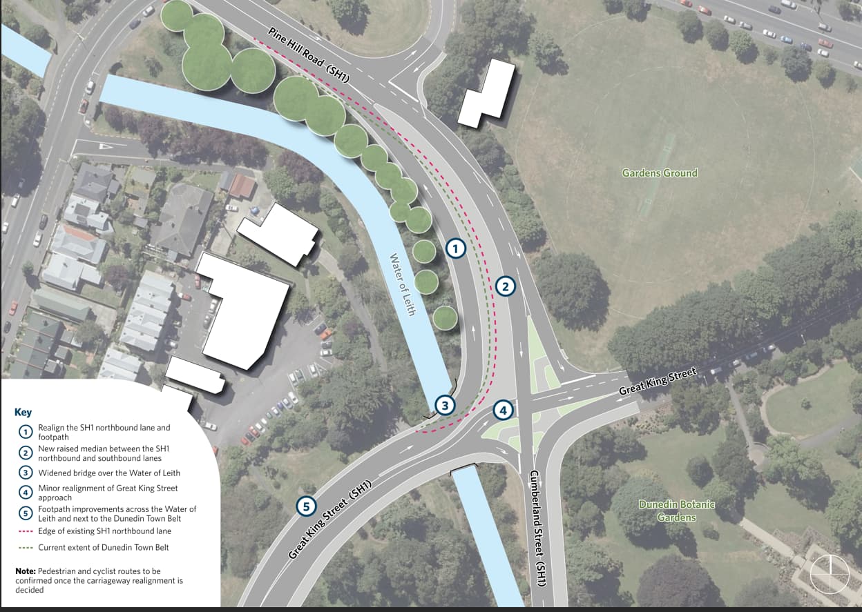
“Our preferred option is to realign the SH1 traffic lane,” he says. “This would improve visibility and safety at the intersection and make it safer and more efficient for people heading to North East Valley.”
This would involve shifting the existing uphill traffic lane about ten metres into an area of Town Belt, requiring about 1000m² of this land. (See map below). The existing bridge over the Water of Leith would be widened. NZTA will work with the Dunedin City Council on ways to compensate for the loss of public land.
What were the other options for that intersection?
Several options for making the SH1/Pine Hill/Great King St intersection safer were investigated and discussed with key stakeholders including the Dunedin City Council and road freight operators.
These included traffic signals and an overpass to separate SH1 traffic from vehicles using Great King Street. The overpass option was not progressed for several reasons: the cost, construction challenges, proximity to the Water of the Leith and environmental impacts, says Mr Duncan. The traffic signal option was not taken further given the significant safety concerns if a heavy vehicle lost traction or could not stop on the hill.
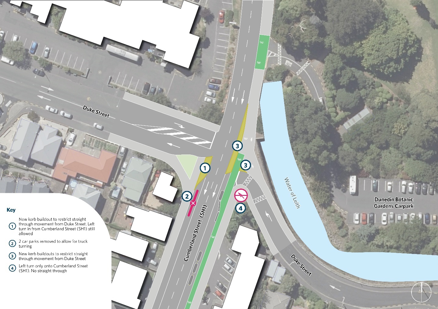
“NZTA’s preferred option would also increase the safety of the nearby Duke Street/SH1 Cumberland Street intersection. There were nine crashes there between 2019 and 2023, two-thirds of them caused by drivers trying to cross two busy lanes of the highway to Duke Street’s western side. To make this intersection safer, we are proposing to remove the straight-through movement, and only allow left turns out of Duke Street on the eastern side to SH1 going south. We want to hear what people think of this idea also.”
Proposed changes for Duke St intersection:
-
Full details on all the proposed improvements for this SH1 Dunedin corridor are available on the project website https://www.nzta.govt.nz/projects/sh1-dunedin-improvements/ along with details on how to provide feedback.
-
More information about NZTA’s proposed improvement plans for SH1 and SH88 St Andrew Street to support transport access to the new Dunedin Hospital, will be available in the second half of 2025.